Lee Still an Intensifying Powerful Category-5 Major Hurricane
09/08/2023, 8:53 am EDTNorth Atlantic Basin Tropical Cyclone Season More Active Than Normal at Midpoint
09/12/2023, 11:44 am EDTHighlight: 97L could be a problem, after Lee.
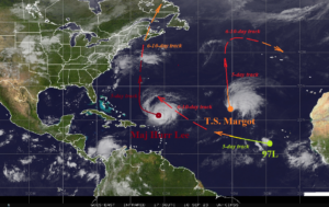
Fig. 1: The North Atlantic basin and 1-5-day plus 6-10-day forecast tracks of Lee, Margot, and 97L.
Discussion: Lee will return to major hurricane status shortly and continue a slow west-northwest trek until mid-week before turning northward late week (Fig. 1). According to NOAA/NHC, Lee will be a major hurricane west of Bermuda in 5 days. The 6-10-day forecast using a consensus of the GFS and ECM takes Lee into western Nova Scotia as a hurricane next weekend. A slight west deviation toward New England is possible early next weekend. Tropical Storm Margot will become a hurricane by Tuesday and drift slowly northward all week. In the 6-10-day period, Margot gradually turns toward the east. Tropical Disturbance 97L formed earlier today and is forecast by tropical cyclone models to become a tropical storm by WED/THU in the central tropical North Atlantic. This system is likely to follow a similar path as Lee and intensify into a hurricane in the 6-10-day period. In the 11-15-day period, there is risk to the East Coast of a hurricane although risk is low for the Gulf of Mexico.