Unique Synoptic Weather Pattern Causes Flash Fires in Canada
06/11/2023, 11:07 am EDT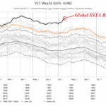
Record Warm Global Temperatures Caused by Marine Heat Waves
07/18/2023, 2:15 pm EDT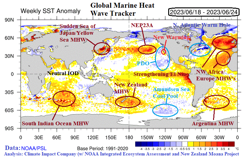
Fig. 1: Global weekly SSTA provided by NOAA and annotated marine heat wave’s plus cool pool locations.
Executive summary: Climate Impact Company is following 7 global marine heat waves (MHW) as the mid-point of 2023 approaches. The largest MHW stretches across the eastern North Atlantic basin and is a repeat of the 2022 episode although displaced slightly westward. Last year, the MHW surrounding Europe was the catalyst to warming the atmosphere, amplifying high pressure and causing historic drought. So far this summer season, the attendant upper ridge is stretched across Northwest Eurasia and monitoring for returning summertime drought and attendant heat is ongoing. Also watched closely is whether MHW NEP23A in the Northeast Pacific can shift east and reach the coast as observed during the last El Nino event in 2014-15. The merging MHW and El Nino in 2015 caused warm ENSO intensity to rival 1982 and 1997 episodes. Recently, a MHW has formed in the Sea of Japan to Coastal China causing an upper ridge pattern to amplify and bring horrific hot weather with developing drought to Northeast China. In the southern hemisphere, the semi-permanent MHW surrounding New Zealand has intensified. MHW’s in the South Indian Ocean and east of Argentina persist. Each MHW is accompanied by a pattern-shaping upper-level high-pressure ridge.
Discussion: According to NOAA’s California Current Integrated Ecosystem Assessment, marine heat wave NEP23A located off the U.S. West Coast formed in May 2023 (Fig. 1). NEP23A is essentially a continuation of NEP22A which weakened temporarily during early spring. NEP22A was the 4th most intense and 2nd longest duration MHW on record for this region. Global SSTA forecasts indicate NEP23A will stay off the West Coast of North America. However, during the past couple weeks, small areas of warm SSTA have emerged off the California and Baja California Coast. During the last full-tilt El Nino in 2015, the most intense MHW on record spread across the Northeast Pacific. Consequently, the 2015 El Nino rivaled 1997 and 1982 as the strongest El Nino’s on record. Close monitoring for this potential hook-up between warm ENSO and a MHW is monitored closely in 2023.
Elsewhere in the northern hemisphere, a MHW has developed suddenly during the past month centered on the Sea of Japan, Yellow Sea, and East China Sea. Global SSTA forecasts anticipate this MHW expanding and strengthening. Typical of MHW’s, the atmosphere responds with an amplified upper ridge pattern that can cause heat waves and drought to develop quickly and this MHW Correlation has developed over Northeast China (Fig. 2).
A large MHW forming off the Northwest Coast of Africa during springtime has expanded westward and northward. An additional MHW is present off Western Europe. In response a large high-pressure ridge, the strongest in the northern hemisphere during June, has emerged over West/Northwest Europe.
Cool pools are also monitored. The semi-permanent North Atlantic warm hole (NAWH) typically located over the Labrador Sea to south of Greenland the past 10 years shifted westward this year and is locked-in off the Northeast U.S. Coast. This feature has caused a chilly MAY/JUN in the Northeast U.S. A second cool pool off the West Coast of North America is related to the cool phase of the Pacific decadal oscillation (-PDO) and leftover from the 2020-23 La Nina climate. The -PDO pattern is stubbornly persisting despite the evolution of El Nino.
Upper air ridge and trough patterns in response to mid-latitude warm/cool SSTA regions can also cause downstream compensating pressure systems (CPS). As an example, the MHW well-correlated to the upper ridge over Northwest Europe in June is compensated for by a large upper trough cooling Central Asia. Similarly, in-between the -PDO and NAWH trough patterns on each coast of North America, an upper ridge has been induced in-between across Canada causing the worst fire season on record for that nation.
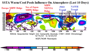
Fig. 2: Northern hemisphere 500 MB anomalies for June 14-23, 2023, identifying upper air patterns associated with warm and cool SSTA regions.
In the southern hemisphere, the New Zealand Moana Project maintains presence of a strong MHW surrounding New Zealand most prominently off the East Coast of South Island. The MHW is expected to strengthen well into July. The South Indian Ocean MHW has shifted slowly eastward the past several months. The upper air pattern during mid-June identifies the correlation between the warm SSTA regions and amplified upper-level ridge areas (Fig. 3). A set of compensating pressure systems have emerged over the south coast of Africa and Australia. The Argentina MHW has weakened slightly but remains well-correlated with an upper-level ridge across and east of Argentina. The Amundsen Sea cool pool is well-correlated with an upper trough southwest of South America.
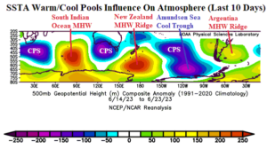
Fig. 3: Southern hemisphere 500 MB anomalies for June 14-23, 2023, identifying upper air patterns associated with warm and cool SSTA regions.