Climate/Agriculture Research: Status of Global Marine Heat Waves (and Warm Holes)
05/29/2023, 9:06 am EDT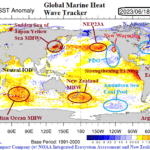
Status of Global Marine Heat Waves Update
06/25/2023, 7:18 pm EDTExecutive summary: Exceptional climate regimes require a close review as to their catalyst to understand how the pattern developed to help mitigate risk, if possible, to similar future circumstances. The record-strength Canadian fire season of 2023 (so far) was caused by a set of unique circumstances all occurring at once to promote a flash fire acceleration during mid-to-late spring 2023. A review of the unique synoptic weather pattern causing the Canadian fires is provided.
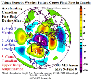
Fig. 1: The 30-day upper-air pattern based on 500 MB anomalies for the northern hemisphere valid May 9-June 8, 2023.
Discussion: A unique synoptic weather pattern present during late first third of May to early June caused an acceleration and widening of an already impressive Canadian fire season. Following this flash fire regime, Canada continues to experience their worst fire season on record.
During late spring an unusually strong polar vortex in the stratosphere extended downward into the troposphere as identified by the 500 MB anomaly analysis for May 9-June 8, 2023 (Fig. 1). The exceptional polar vortex intensity is identified by a positive phase arctic oscillation (+AO) spiking at +2.6 on May 18 and +1.9 on May 28 according to NOAA/CPC. To compensate for the deep polar vortex, 4 amplified longwave upper-level high-pressure ridge areas formed at the Dateline, Central Russia, just west of U.K., and across Canada.
Although the official onset of El Nino was recently announced by NOAA/CPC, the catalyst to the El Nino trigger was a month-long period (Fig. 2) of strong negative phase southern oscillation index (-SOI), a classic sign of a “pulse” of El Nino climate. The near 30-day -SOI pattern was the first since 2019. During this regime, an elongated convective rain producing upper trough stretches across the low-latitude subtropics most evident in North America on the U.S. Gulf of Mexico Coast. The attendant convective rains release latent heat poleward which warms the atmosphere and causes the already present upper-level ridge patterns to amplify. Consequently, anomalous warmth and dryness adding fuel to fires evolved quickly during May.
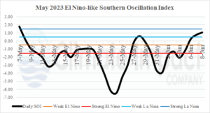
Fig. 2: The daily El Nino-like negative southern oscillation index (-SOI) for May into June 2023.
Of course, a fire season historically wide in aerial coverage and intensity is initially set by a long duration dry climate or/and a rapidly accelerating dry near-term climate. During 2014-2022 after the Northeast Pacific marine heat wave (MHW) and North Atlantic warm hole (NAWH) oceanic regimes developed, the upper air pattern across Canada has generally favored a drier/warmer than normal ridge in the west and southeast continent (Fig. 3). Long-term dryness is certainly present across Western Canada.
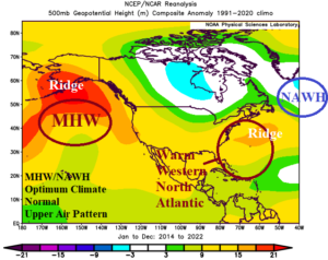
Fig. 3: The 2014-2022 prevailing upper air pattern across North America enhanced by persistent marine heat waves in the Northeast Pacific and cool pool of water south of Greenland known as the North Atlantic warm hole.
During Q2/2023 the NAWH pattern evolved and shifted farther west than observed (since 2014). A colder than normal pool of ocean water enhanced by a chilly Labrador Current spread across waters off the Northeast U.S. Coast and southeast of the Canadian Maritimes during APR/MAY and into June (Fig. 4). The Semi-permanent (NAWH) upper trough also shifted west to east of New England and to compensate, the upper ridge shifted to Eastern Canada causing rapidly developing dry soils following a winter with below normal snowfall (Fig. 5).
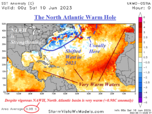
Fig. 4: The 2014-2022 prevailing upper air pattern across North America enhanced by persistent marine heat waves in the Northeast Pacific and cool pool of water south of Greenland known as the North Atlantic warm hole.
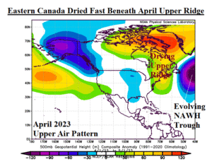
Fig. 5: The April 2023 upper air pattern across North America identifying the most concentrated period of drying in East Canada due to high pressure.
Conclusion: A unique set of synoptic weather patterns caused the record-strength Canadian fire season. Long-term drought across Western Canada was in-place due to a semi-permanent upper-level ridge associated with the warming of the Northeast Pacific Ocean during much of the past decade. Long-term dryness is also present across much of Southern Canada due to a semi-permanent upper trough over Central Canada limiting moisture advection from the south and occasionally across East/Northeast Canada due to a semi-permanent upper ridge over the warmer than normal West North Atlantic Ocean.
While the long-term climate identified was a likely contributor to initiating the Canadian fire season, unique weather pattern synoptics from mid-to-late spring drove the flash fire acceleration observed in May. Flash fire is an expression used to parallel flash drought as the adverse climate condition discussed came on rapidly.
To compensate for an unusually strong polar vortex, an upper ridge formed over 4 sectors of the northern hemisphere middle and upper latitudes including Canada during May. The upper ridge was made stronger by presence of a long duration negative southern oscillation index (-SOI) inspired by a transient convection phase of the Madden Julian oscillation (MJO) which eventually inspired El Nino onset June 8th. The MJO/SOI combination caused southern latitude convective rains during May and the release of latent heat warmed the atmosphere to the north further strengthening the Canadian ridge. The result was widespread anomalous warm (and record hot) and dry climate in much of Canada accelerating an already bad fire season.
The unusual spread of fires into Southeast Canada was accelerated by presence of a warm/dry ridge beginning in April which developed in response to a deep upper trough southeast of Canada across the rapidly cooling ocean surface east of New England.