Northern Hemisphere Winter 2023-24: Increased Risk of SSW Events Triggering Arctic Air Generation
08/16/2023, 12:25 pm EDTTo Date, U.S. Summer 2023 Not That Hot
08/24/2023, 8:24 am EDT
Fig. 1: Satellite view of the North Atlantic basin and primary features.
Today’s discussion: Tropical Disturbance 91L is located north of the Yucatan Peninsula in the east-central Gulf of Mexico (Fig. 1). This feature is moving due west to the south of the East-central U.S. upper ridge. 91L is gaining convection and should transition into a tropical depression by tonight and weak tropical storm tomorrow morning making landfall south of Corpus Christi mid-to-late morning (Fig. 2). Locally high wind and heavy rain is likely for the Corpus Christi area southwest to near Brownsville. This system will move inland quickly and weaken. Elsewhere, there are 4 tropical systems to monitor. Most potent is Tropical Storm Franklin to the south of the Dominican Republic forecast to turn north and unload heavy rain on Hispaniola and possibly Puerto Rico tonight and Tuesday. This system crosses the high terrain of Haiti but is forecast by NOAA/NHC to re-emerge north of Hispaniola midweek and turn northeast redeveloping into a hurricane in 5 days. Tropical Storms Gert and Emily will weaken and dissipate over the next 1-3 days. Tropical Disturbance 92L in the outer North Atlantic tropics is forecast to become a tropical storm reaching the central North Atlantic subtropics in 5 days.
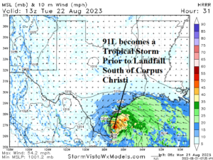
Fig. 2: HRRR forecast of 91L becoming a weak tropical storm prior to moving inland south of Corpus Christi later tomorrow morning.