Early Solar Maxima 25 Forecast (by NOAA) and Adjusted Stronger. Surprises Still Possible.
10/30/2023, 10:07 am EDTCentral/East-central Brazil Strengthening Drought Watch Initiated
11/01/2023, 5:37 pm EDTHighlight: 97L emerges south of Puerto Rico, tracks westward and develops.
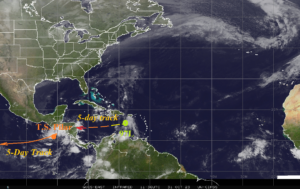
Fig. 1: North Atlantic basin satellite view and current tropical systems.
Discussion: Tropical Disturbance 97L emerges south of Puerto Rico (Fig. 1). This system will drift westward during the next 5 days across very warm water of the Caribbean Sea and is likely to steadily organize. In 5 days, a hurricane is possible. This system may stay in the Western Caribbean next week and continue to strengthen. Tropical Storm Pilar in the East Pacific is expected to shift westward.
Well-known is the tendency for increasing tropical cyclone activity in recent decades due to a shift into the warm cycle of the Atlantic Multi-decadal oscillation (Fig. 2). Most apparent is the increasing number of tropical storms while hurricanes/intense hurricanes have increased slightly. During the current warm AMO cycle, hurricanes are observed to intensify more rapidly when crossing over warm water. According to Andra Garner’s white paper “Observed increases in North Atlantic tropical cyclone peak intensification rates” the number of category-1 hurricanes intensifying to a major hurricane within 36 hours has doubled in the modern warming of the North Atlantic era.
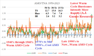
Fig. 2: The 1950-2023 Atlantic multi-decadal oscillation/tropical North Atlantic index and tendency for the latest warm phase to produce more tropical storms.