Why Have Week-2 U.S. CDD Forecasts Been Too Hot?
08/02/2022, 5:42 am EDTPresence of TUTT Leads to a Revised 2022 Tropical Cyclone Season Forecast for Much Lower Amount
09/14/2022, 4:42 am EDT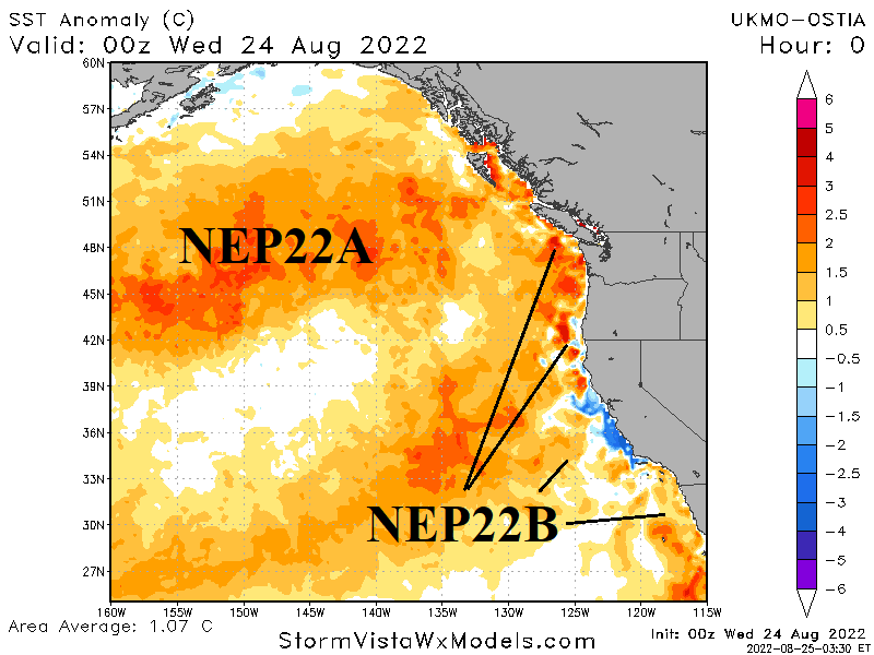
Executive summary: In October 2014 two regions of exceptionally warm surface water in the northeast Pacific and off the California Coast merged to create one large “warm blob”. The warmer-than-normal ocean surface caused the atmosphere above to also warm and a strong upper-level high-pressure ridge formed extending cross-polar from Alaska. The downstream influence was to produce a “polar vortex” regime into the East U.S. which in-turn caused 14 states to have all-time top-10 cold months of November including near record chill in Mississippi and Alabama. Currently, northeast Pacific marine heatwave NEP22A and U.S. West Coast marine heat wave NEP22B are being monitored for the same type of merge. If that merge occurs into mid-autumn, the upper air pattern will shift colder for the East U.S.
Discussion: Marine heatwave NEP22A which formed in 2021 is located in the northeast Pacific with an eastward extension reaching the West Coast of Canada (Fig. 1). SSTA are as high as +8C within this “warm blob”. Earlier this year, a second marine heat wave (NEP22B) developed off the U.S. West Coast and southward to coastal Baja California (Fig. 2).
The warming waters off the U.S. West Coast foreshadowed the upper-level ridge pattern causing the hot and dry August in the Northwest U.S. Anomalous warm waters near and south of Baja California have fueled an active Southwest U.S./Mexico wet monsoon season.
Once again, regional SSTA patterns are having a dominant influence on climate frequently out-weighing effects of large-scale regimes such as ENSO.
The concern with NEP22A and NEP22B is that each marine heatwave could merge for late 2022 similar to a 2014 episode (Fig. 3). The anomalous warm SSTA pattern in the northeast Pacific Ocean during autumn 2014 caused the air aloft to also warm leading to an amplified high-pressure ridge which extended well to the north across Alaska. The high-pressure “ridge bridge” extended to Siberia and the polar ice cap and tapped early season cold air which surged into North America and the Eastern U.S. during November.
The downstream influence of the Alaska “ridge bridge” was an unexpected deep upper trough in the East U.S. (Fig. 4) made stronger by the cross-polar flow of low-level cold air. November 2014 featured 14 states having top-10 all-time cold with strongest cold anomalies across Arkansas, Louisiana and Mississippi (Fig. 5).
Close monitoring of NEP22A and NEP22B for a potential merge which causes widespread warming of the northeastern Pacific Ocean leading to an upper air pattern that could cause a chilly start to the 2022-23 cold season in the East U.S. is monitored very closely.

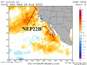
Fig. 1-2: The northeastern Pacific Ocean SSTA analysis identifies two “warm blobs” (NEP22A and NEP22B).
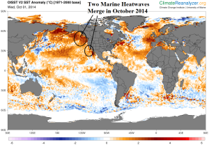
Fig. 3: The concern is that NEP22A and NEP22B will merge and create northeast Pacific Ocean warming similar to October 2014 which caused a dramatic influence on the upper air pattern for North America during late autumn.
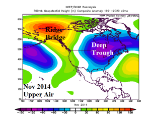
Fig. 4: The November 2014 upper air pattern across North America produced an amplified upper ridge across and north of the warm SSTA zone in the northeast Pacific compensated for by a downstream cold upper trough in the East.
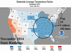
Fig. 5: State temperature rankings for November 2022 produced 14 states with all-time top-10 chill.