East-central U.S. Soils Trending Drier
02/25/2024, 3:26 pm ESTMidday 12Z GFS Unloads >12 In. of Rain California and Alabama
02/28/2024, 12:53 pm EST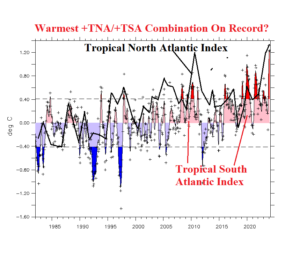
Fig. 1: Plotting annual tropical North Atlantic (TNA) and tropical South Atlantic (TSA) indices reveals the warmest tropical Atlantic SSTA regime on record.
Discussion: The warmest SSTA on record for both the tropical South Atlantic and North Atlantic are occurring simultaneously (Fig. 1). The daily tropical South Atlantic (TSA) index is a robust +1.36C while the tropical North Atlantic (TNA) index is an impressive +1.48C. Combined with El Nino warming across the tropical Pacific and an impressive SSTA average of +1.12C across the IOD region of the Indian Ocean, the global tropical oceans are the warmest observed within the confines of historical data (Fig. 2). A preliminary view of the influence on tropical climate during DEC/JAN/FEB 2023-24 indicates enhanced tropical rains due to the presence of El Nino underachieved as wet anomalies were smaller than usual. Proposed is the lack of zonal SST thermal gradient across the tropics suppressed the expected vertical motion normally associated with El Nino. The record warm +TNA pattern in the main development region (MDR) for North Atlantic hurricanes coupled with an expected shift in ENSO phase from El Nino to La Nina supports an extremely active North Atlantic tropical cyclone season ahead in 2024.

Fig. 2: Daily global SSTA analysis and SSTA within important tropical regions.