Indian Ocean Dipole Outlook: Possible Negative Phase by July
04/14/2020, 12:50 pm EDT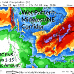
Heavy Rain Set-up for the Midwest/Northeast U.S. Corridor
04/23/2020, 4:38 pm EDT


Fig. 1-4: The Gulf of Mexico SSTA pattern is among the warmest observed for springtime and the leading contributor of moisture to an active severe weather/excessive rainfall pattern across the Southeast States the latest of which occurs today.
Discussion: Another California upper trough has shifted east, similar to last week at this time and the same result will occur…entrainment of unusually warm Gulf of Mexico moisture (into the trough) and catalyst for another exceptional severe weather/excessive rainfall event.
Currently, a flash flood watch is issued from central Mississippi east to central Georgia with many parts of central portions of Mississippi and Alabama already encountering flooding and flash flooding in central Alabama (Fig. 5). The Mississippi/Alabama flooding is due to heavy rainfall just north of a warm front roped across the southern third of each state. Tornado risk is still well to the west. A tornado watch (Fig. 6) is issued for Southeast Texas including the Houston, TX area (where tornado risk is evident just west and northwest of the city now).


Fig. 5-6: Current NWS warning, watch and advisory areas and a tornado watch issued for eastern Texas valid to 3PM CDT.
Into midday the tornado threat in Southeast Texas expands and covers much of that region including the Houston area (Fig. 7). The heavy to excessive rains across central Mississippi to central/northeast Georgia continue with embedded strong thunderstorms. Widening flash flooding in this zone. By mid-afternoon lingering severe thunderstorms and possible tornadoes are affecting Southeast Texas and expanding across Louisiana (Fig. 8). Along the warm front another area of severe storms and possible tornadoes is forming from central Mississippi to central Georgia and eastward to the Savannah area. This second zone remains the area of most intense heavy rain/flash flooding mid-afternoon.


Fig. 7-8: HRRR radar depiction forecasts identifying severe weather/excessive rainfall location for Noon and 3PM CDT.
By early evening severe storms/tornado risk affects two areas…Louisiana and into Mississippi and also central Mississippi to central Georgia (Fig. 9). Any of these storms can produce heavy rain/flash flooding. However, the central Mississippi to central Georgia rainfall is so persistent that flash flooding becomes life threatening and is complicated by tornado risk. The tornado risk begins to ease but certainly does not end mid-evening and involves many sectors (Fig. 10).


Fig. 9-10: HRRR radar depiction forecasts identifying severe weather/excessive rainfall location for 6PM and 9PM CDT.
The severe weather/excessive rainfall episode will carry into Monday morning (Fig. 11-12). The HRRR model indicates rainfall amounts approaching (or exceeding) 10 inches in parts of central Mississippi, Alabama and Georgia (Fig. 13).


Fig. 11-12: HRRR radar depiction forecasts identifying severe weather/excessive rainfall location for Midnight and 3AM Monday CDT.

Fig. 13: HRRR rainfall estimates for the next 24 hours.