Global Soil Moisture Trend and Forecast Report
08/09/2023, 8:17 am EDTERCOT Heat to Become Less Intense: PJM-West Heat Spike Possible
08/11/2023, 11:59 am EDT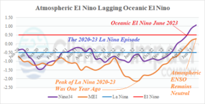
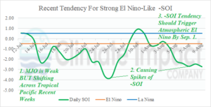
Fig. 1-2: The JUN-20 to present monthly Nino34 SSTA and multivariate ENSO index (above) and 30-day daily southern oscillation index.
Discussion: The 2020-23 La Nina rivaled 1954-56, 1973-76, and 1998-01 (using Nino34 index) as most lengthy cold ENSO episodes since 1950. Based on multivariate ENSO index (MEI), La Nina 2020-23 was arguably the strongest La Nina since 1950. The Nino34 index is the convention to identify oceanic ENSO phase. MEI is an index that explains the atmospheric reaction to the equatorial Pacific SSTA pattern. While oceanic El Nino onset was announced by NOAA in June, the atmosphere is lagging with a lingering memory of the 2020-23 lengthy La Nina keeping atmospheric ENSO in neutral phase. However, recent signs that MEI should shift into El Nino phase next month are appearing. A daily index that identifies the atmospheric response to ENSO is the southern oscillation index. (SOI). Increased tropical convection in the West Pacific tropics (and responsible for igniting the West Pacific tropical cyclone season) is extending eastward. Signs of a weak east-shifting Madden Julian oscillation (MJO) are evident. In response, SOI is starting to spike into the El Nino-like negative phase (late July and now). The tendency for -SOI spikes should push MEI into atmospheric El Nino climate in September. For now, we’re not quite into an El Nino climate despite the vigorous warming of the eastern equatorial Pacific. An interesting observation is that during the 2020-23 La Nina, MEI (atmospheric La Nina) was almost always much stronger than oceanic (Nino34) La Nina.