Australia Winter Climate Conflict Regarding Indian Ocean Dipole
04/09/2024, 4:42 am EDTQuarter 1 of 2024 was 5th Warmest on Record in U.S.
04/11/2024, 4:14 pm EDTExecutive summary: Officially, the ENSO phase forecast for 2024 remains unchanged with a transition from lingering El Nino now rapidly to neutral ENSO by May and trend into La Nina for the second half of 2024 although uncertainty in the intensity. As a reminder, the very active North Atlantic basin hurricane season forecast indicated by Colorado State University, Tropical Storm Risk U.K., and Climate Impact Company are mostly reliant on the warm sea surface temperature anomalies of the North Atlantic tropics and subtropics and shift into a low shear environment in the upper atmosphere by La Nina. Climatology of ENSO and North Atlantic tropical cyclone activity indicates a moderate strength La Nina propels a super active season while strong La Nina can suppress activity due to presence of a tropical upper tropospheric trough (TUTT). Consequently, a less intense La Nina is a larger problem in the North Atlantic tropical cyclone season as activity increases with this ENSO regime. The 2024 La Nina intensity is an increasing question. In this report, detailed is the emergence of a positive phase Indian Ocean dipole (+IOD) forecast by Australia Bureau of Meteorology (ABOM). +IOD patterns (generally) occur with El Nino and never with La Nina. The ABOM forecast raises the risk of a weaker La Nina (ECMWF) or ENSO staying neutral (Meteo France) versus the stronger La Nina forecast by NECP CFS V2. How quickly the Nino34 SSTA cools during the next 1-3 months is the key to how intense La Nina becomes later in 2024.
Discussion: A potential issue has arisen regarding the 2024 ENSO forecast. The Australia Bureau of Meteorology (ABOM) announced that the Indian Ocean dipole (IOD) is forecast to return to the positive phase in May lasting several months into early Q4/2024 (Fig. 1). ABOM identifies +IOD years (since 1950) as 1961, 1963, 1967, 1972, 1994, 1997, 2006, 2015, 2019, and 2023. In each of these analog years (except for 1961 and 1967) El Nino was present. Of the 10 analog years, 5 featured strong El Nino. The consensus of most dynamic and statistical ENSO phase forecast models is La Nina will develop during the second half of 2024 (Fig. 2). However, there are several global SSTA models NOT forecasting La Nina and instead projection neutral ENSO such as Meteo France during August (Fig. 3). Other commonly referred to ENSO forecasts have La Nina such as ECMWF (Fig. 4) although not nearly as strong as NCEP CFS V2 (Fig. 5). If the +IOD develops, La Nina 2024 will be weak.
A key diagnostic to determine ENSO phase change ahead is the observation and trend of subsurface temperatures in the equatorial Pacific to the east of the Dateline. The 4-month sequence of equatorial Pacific subsurface temperature anomalies reveal the cooling trend required to cause an ENSO phase change from El Nino to La Nina (Fig. 6). The cooling observed so far in April (Fig. 7) is robust and has similarity to April 1998 (Fig. 8) when strong El Nino transitioned to strong La Nina, similar with expectations of the NCEP CFS V2 model.
During El Nino 2023-24, much was made of the lack of correlation between the Nino34 SSTA, the conventional ENSO phase indicator, and multi-variate ENSO index (MEI) which indicates the reaction of the atmosphere to tropical AND subtropical sea surface temperature anomalies (SSTA). During the 2023-24 El Nino, the MEI was weak suggesting the anomalous warmth outside of the equatorial warming associated with El Nino and (also) in the subtropics was causing a weaker El Nino climate. NOAA has discontinued MEI as of early this year. Going forward, the southern oscillation index (SOI) receives increased attention due to its inferring of the atmospheric condition in response to equatorial SSTA regimes. Note that SOI produced occasional El Nino spikes during the 2023-24 El Nino episode (Fig. 9) and the weaker (El Nino) signature was similar with the MEI diagnostic.
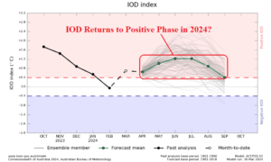
Fig. 1: Australia Bureau of Meteorology forecasts return of the positive phase of the Indian Ocean dipole by mid-year.
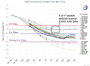
Fig. 2: International Research Institute for Climate and Society dynamic and statistical Nino34 SSTA forecasts through the remainder of 2024.
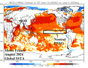
Fig. 3: Meteo France is forecasting +IOD and neutral ENSO for August 2024.
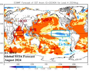
Fig. 4: ECMWF projects weak La Nina with +IOD for August 2024.
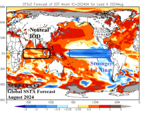
Fig. 5: NCEP CFS V2 projects stronger La Nina without +IOD for August 2024.
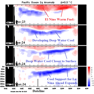
Fig. 6: Equatorial subsurface Pacific Ocean upper ocean heat analysis for the past 4 months identifies developing cooling supporting an ENSO phase change ahead.
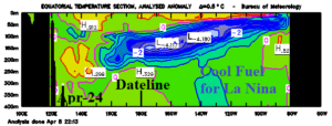
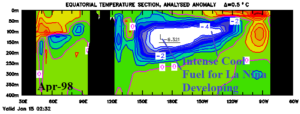
Fig. 7-8: Equatorial subsurface Pacific Ocean upper ocean heat analysis for April 2024 (top) compared to April 1998, a year when a strong oceanic El Nino similar with 2023-24 transitioned to a strong La Nina similar with the NCEP CFS V2 forecast.
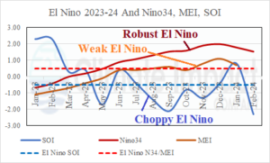
Fig. 9: Climate diagnostics used to identify ENSO phase and intensity indicate differences for the 2023-24 El Nino episode.