March 2024 Global Soil Moisture 3-Month Observation Trend and Forecast
03/13/2024, 3:51 am EDTHotter Than Normal MAY-SEP U.S. CDD Forecasts
03/19/2024, 12:48 pm EDT 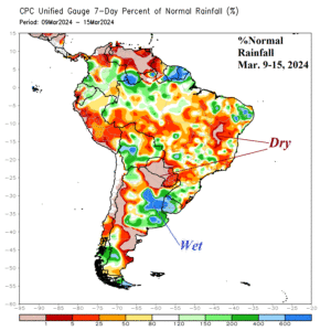
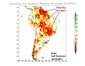
Fig. 1-2: Percent of normal rainfall for Mar. 9-15, 2024, and daily soil moisture rankings across South America.
Discussion: During the past week, sparse rainfall coupled with anomalous heat plagued Paraguay and much of Brazil (Fig. 1). The wet zone was Northeast Argentina and Uruguay. Late calendar summer soil moisture conditions remain poor across much of the Brazil second corn crop due to worsening drought (Fig. 2). The northwest Brazil drought across Amazonia continues. Part of the (climate) problem producing the late summer dryness and heat is that South America, particularly Brazil, is located in the subsidence portion of the exposure to a strong Madden Julian oscillation (MJO) episode in the tropical West Pacific. The MJO is forecast to shift eastward over the next 2 weeks, the 5th MJO event to travel across the equatorial Pacific since last September. As the MJO shifts east, a tendency for drier weather in Argentina and a wetter regime in Brazil will generate (Fig. 3-4). Long-term? Once the wetter MJO influence on Brazil climate abates in early April, dryness is likely to return with a wet shift back to Argentina.
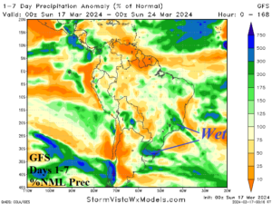
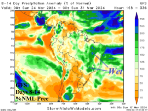
Fig. 3-4: GFS 1-7-day and 8-14-day percent of normal rainfall forecast across South America.
The convection phase of the MJO across Maritime Continent into the equatorial West Pacific is a tropical cyclone generator for Australia. Fortunately, Tropical Depression 18 is forecast to stay off the northwest coast of the continent. However, intensifying Category-2 Tropical Cyclone Megan is a slow-mover into Northern Australia and carries excessive rainfall through North-central Australia this week bending southeastward in the extended-range (Fig. 5-6). Additional tropical cyclone risks are forecast by GFS in the 8-14-day period north and northeast of Australia.
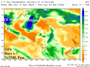
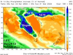
Fig. 5-6: GFS 1-7-day and 8-14-day percent of normal rainfall forecast across Australia.
The influence on climate across the U.S. by the transient Pacific MJO episode also affects the U.S. Corn Belt weather profoundly. In the short-term, the wet influence on climate of the MJO is west of the U.S. leaving the U.S. Corn Belt mostly dry this week (Fig. 7). However, in the 8-14-day period, Pacific (and Gulf of Mexico) moisture is heavily involved with the U.S. storm track causing 3-5 in. of rain centered on parched Iowa and the Southeast U.S. (Fig. 8).
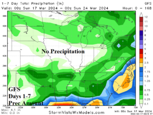
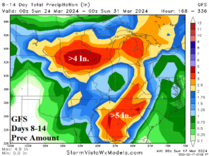
Fig. 7-8: GFS 1-7-day and 8-14-day precipitation amount forecast for the U.S. AG Belt.