Recent Precipitation Forecast Verification days 11-15 U.S. AG Belt and Europe
04/11/2024, 9:56 am EDTLatest NOAA/CPC Long-lead Climate Outlooks; Hot Risk Most of U.S. Summertime
04/18/2024, 11:52 am EDT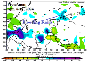
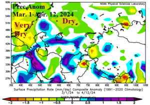
Fig. 1-2: Flooding rainfall was observed recently south of the Black Sea region and Russia’s Kurgan Region (left) whereas dry concerns have dominated Southwest Russia since Mar. 1st (right).
Discussion: Heavy rain has caused flooding in Russia’s Kurgan region in recent days (Fig. 1). This part of the Russia spring wheat growing area. Additional flooding is expected due to the rising Tobol River through this region. Precipitation climate concerns since late winter have mostly been widespread dryness across Southwest Russia (Fig. 2) coupled with lack of snow causing steady drying of soils. The 15-day outlook for Europe and Western Russia features a drier trend returning for the Kurgan Region extending westward to Caspian Sea (Fig. 3). Southwest Russia receives a showery regime featuring occasional rain to help ease (slightly) the recent dry soil trend. Heavier rain continues plague Germany and vicinity during the last half of April. The temperature outlook remains familiar for the second half of April featuring strong anomalous warmth for areas east and northeast of the Black Sea region while wet weather cools much of Central and Northern Europe (Fig. 4).
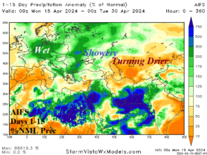
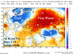
Fig. 3-4: AIFS 15-day percent of normal precipitation and AI Forecast Net V2 15-day temperature anomaly forecast across Europe and Western Russia.
Severe thunderstorms plague the Midwest U.S. today through Wednesday (Fig. 5-7). Tornado risk affects Nebraska to Texas today, Iowa and Missouri tomorrow, and Indiana/Kentucky on Wednesday.
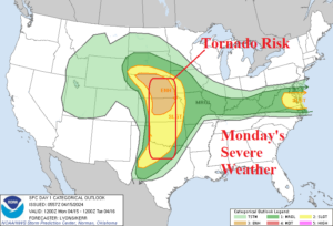
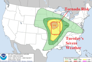
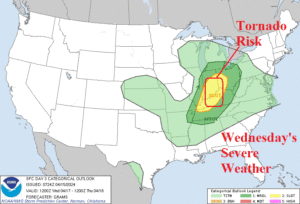
Fig. 5-7: NOAA/SPC projects severe thunderstorms across the Midwest U.S. during the next 3 days.
The general trend with over the weekend forecasts was drier in Brazil and wetter across Argentina. Last night’s 15-day ECM ENS percent of normal rainfall forecast stresses dryness in East Brazil while Northeast Brazil and much of Argentina are wet (Fig. 8). Skill scores from the past 2-4 weeks for Brazil by all models is too wet although ECM ENS has the least dramatic error. The new AIFS from ECMWF 15-day projection is similar with the ECM ENS (Fig. 9).
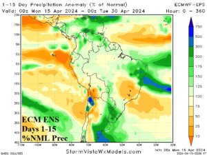
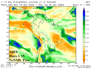
Fig. 8-9: ECM ENS and AIFS 15-day percent of normal rainfall forecast across South America for comparison purposes.