Early Polar Ice Expansion Shapes Eurasia Climate
10/05/2022, 4:53 am EDTUpdating Global SSTA, Soil Moisture and November 2022 Global Climate Expectations
10/23/2022, 1:12 pm EDT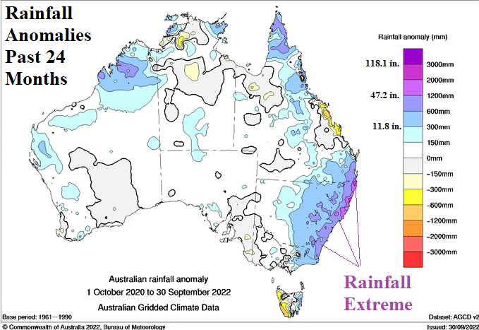
Executive Summary: Another extreme rainfall event has struck Australia, this time centered on parts of the Victoria State including the city of Melbourne. The extreme rainfall events have become commonplace in southeast Queensland, eastern New South Wales and into Victoria during the past 2 years (Fig. 1). Parts of east-northeast coastal New South Wales have received 1200-2000 mm (47.2-78.7 in.) above normal in this timeframe. La Nina is certainly a contributor to the wet pattern. However, the excessive character of the coastal rains may be related to the semi-permanent “warm blob” of SSTA surrounding New Zealand and stretching eastward across the subtropical South Pacific Ocean.

Fig. 1: Australia Bureau of Meteorology 24-month rainfall anomalies identifying the extreme amount observed in east/southeast coastal continent.
Discussion: During early-to-middle spring, the New Zealand “warm blob” is less intense (Fig. 2) but certainly strong enough to help produce a titanic subtropical ridge pattern near New Zealand (Fig. 3). Typical of this established pattern the past several years, the upper ridge is compensated for by a wet upper trough over Eastern Australia enhancing La Nina rains. This set-up helped to cause the Melbourne excessive rainfall event of the past few days.
The New Zealand “warm blob” expands and intensifies during mid-to-late summer as forecast by ECMWF (and other models) by February (Fig. 4).
Once again, summer 2022-23 brings New Zealand “warm blob” enhancement of La Nina rains to Eastern Australia including an increased risk of extreme rainfall events.
However, looking at the long-range possibilities, there is a reasonable chance that the wet climate of the past 2-3 years in Eastern Australia will end and possibly reverse as analogs favor El Nino developing for later 2023 (Fig. 5).
Fig. 2: The 90-day global SSTA forecast identifying regions of SSTA influence on southern hemisphere climate including the semi-persistent New Zealand “warm blob”.
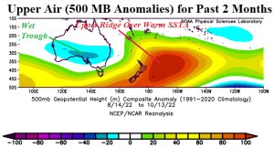
Fig. 3: 500 MB anomalies across Australia and the South Pacific for the past 60 days identifying the amplified upper-level ridge over the persistent warm waters near and east of New Zealand compensated for by a wet trough over Australia.
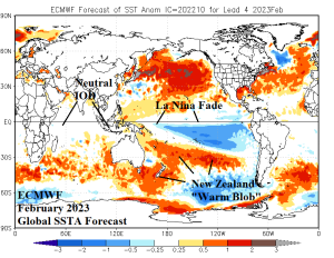
Fig. 4: Once again, by late summer, the New Zealand “warm blob” is expected to expand and strengthen based on the latest ECMWF global SSTA forecast for February 2023. An expanding/intensifying subtropical ridge forms across the warm SSTA region and remains compensated for by the wet trough over Eastern Australia.
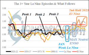
Fig. 5: Based on an analog, the 2020-22 La Nina dominance is expected to end in early 2023 and possibly reverse to El Nino later in 2023.
Conclusion: Climate Impact Company continues to cite the influence of unusually warm (or cool) regional SSTA patterns and their influence on climate patterns including enhancement of ENSO-related climate. During the 2020-22 La Nina expected above normal rainfall in Eastern Australia has become extreme due to the influence of a semi-permanent upper-level low-pressure trough affecting Eastern Australia climate and in-place to compensate for a semi-permanent (titanic) upper-level high-pressure ridge near New Zealand. The upper-level ridge is well-correlated to the presence of a large area of anomalous warm water near and east of New Zealand in yet another example of marine heat waves (or “warm blobs”) which have become common during the past decade.