Southeast Great Plains Drought Risk
07/23/2024, 4:31 pm EDTBuoyant Mid-Troposphere Relative Humidity Promises Busy Season Ahead in North Atlantic Tropics
07/25/2024, 8:57 am EDT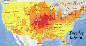
Fig. 1: NOAA extreme heat stress projection for day-7 (next Tuesday).
Discussion: Using the ALL MODELS 15-day max/min temperature forecast, the projected maximum temperature for day-7 (next Tuesday) in the central to southeast Great Plains (Fig. 1) where deep layer soil moisture deficits are located, and presence of persistent hot/dry climate may lead to flash drought, are in the 102F-106F range with heat index near or above 110F. This is the beginning of the strongest part of the heatwave.
The >100F forecast through the next 15 days identifies the emergence of excessive heat and the expanding/intensifying character once into the extended range (Fig. 2-4). Rapidly drying soils including flash drought risk appear during the medium range. NOAA/CPC identifies the northwest and west Great Plains as emerging drought areas and CIC adds the southeast Great Plains.
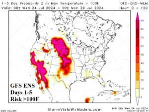
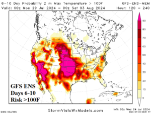
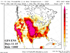
Fig. 2-4: GFS ENS 15-day risk of >100F forecast.
The U.S. population weight CDD forecast explodes to well above normal August 2-8 (Fig. 5). The GFS is the hottest model, but all ensembles are trending hotter. Contributing to the increasing CDD during early August are hotter forecasts in the PJM-East sector.
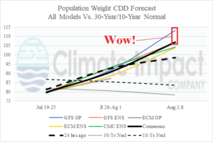
Fig. 5: The U.S. population weight CDD forecast utilizing all models, their consensus, and comparing with yesterday and normal.