Increased Solar Activity/Decrease in Sudden Stratospheric Warming Events
10/04/2023, 11:05 am EDTLongterm Brazil Rainfall Climate Review
10/12/2023, 3:18 pm EDT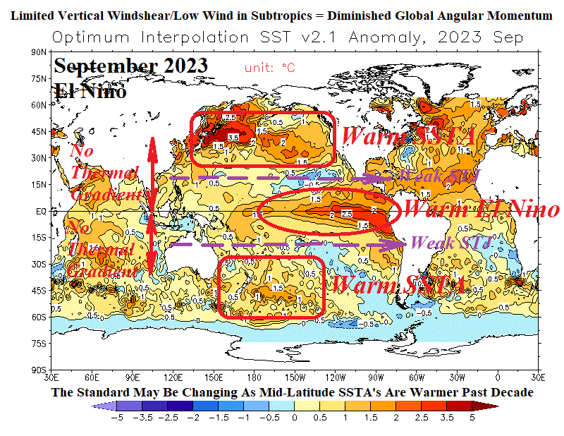
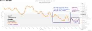
Fig. 1: Global atmospheric angular momentum daily observations from the past 120 days and the 15-day forecast.
Executive summary: Historically, global atmospheric angular momentum (GLAAM) has tendency to increase during El Nino due to increased vertical wind shear and upper-level wind increase in the subtropics of both hemispheres. The increased wind in the global subtropics increases GLAAM. However, despite El Nino presence in late 2023, GLAAM has shifted negative. Proposed is the unusual negative shift in GLAAM is due to the warming of the mid-latitude oceans of the past decade or so lowering or eliminating south-to-north subtropical oceanic thermal gradient, vertical wind shear, and wind aloft.
Discussion: During the past few weeks global angular atmospheric momentum (GLAAM) has shifted into the negative phase and the 15-day forecast indicates the trend continues and strengthens (Fig. 1). The observation is VERY unusual considering the presence of El Nino. During El Nino, strong anomalous warm sea surface temperature anomalies (SSTA) convene in the eastern tropical Pacific Ocean while poleward waters have a tendency for cool SSTA. An example of this configuration is notable during the October 1982 El Nino, one of the strongest warm ENSO episodes on record (Fig. 2). The south-to-north oceanic thermal increase in the subtropics leads to increased vertical wind shear and a stronger than normal subtropical jet stream (in both hemispheres). The stronger wind aloft in the global subtropics adds to GLAAM. A common correlation is +GLAAM with El Nino.
HOWEVER, during the past 10 years the mid-latitude oceans have consistently warmed. Part of this warming is produced by marine heatwaves (MHW) which Climate Impact Company identifies and monitors. The warmer mid-latitude oceans are certainly present now, during the 2023 El Nino (Fig. 3). However, the typical thermal contrast in ocean SSTA from south-to-north across the subtropics is absent and vertical wind shear is diminished and the subtropical jet stream is weak or non-existent. This phenomenon helps to explain the unprecedented 17 tropical storms in the North Atlantic basin during an El Nino summer.
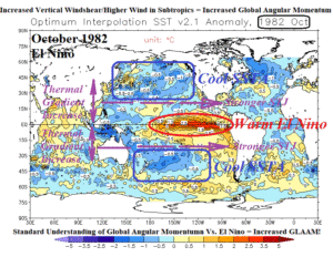
Fig. 2: Global SSTA during the October 1982 El Nino and annotations helping to explain increased GLAAM.
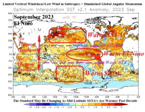
Fig. 3: Global SSTA during the September 2023 El Nino and annotations helping to explain decreased GLAAM.