North America and Europe Winter 2023-24 Are Examples of Climate Change
02/15/2024, 7:27 pm ESTUsing Multivariate ENSO Index, The 2023-24 El Nino Was Very Weak
02/21/2024, 7:02 am ESTDiscussion: Oceanic El Nino is weakening SLOWLY. The Nino34 SSTA cooled slightly last week to +1.5C (Fig. 1). which is down from peak +2.1C last November. All Nino SSTA regions have cooled slightly during the past 2-3 months. El Nino 2023-24 produced a moderate-to-strong oceanic signature ranking as the 7th strongest warm ENSO event since 1950 according to Australia Bureau of Meteorology. However, the atmospheric El Nino lagged with occasional surges of strong negative southern oscillation (-SOI) last JUL/AUG/SEP (Fig. 2) mostly related to an eastward extension of the Madden Julian oscillation (MJO) east of the Dateline. Interestingly, the strongest 18-day -SOI regime has just-ended as atmospheric El Nino 2023-24 peak occurred about 2 months after oceanic peak. Potentially, based on this observation, El Nino climate may linger a couple months after ENSO neutral arrives as forecast by most models later during Q2/2024. As always, keys to ENSO phase change are the observations and trend of subsurface equatorial Pacific Ocean temperature anomalies. A daily check reveals a large area of much cooler water from about 75 to 250 meters depth shifting across the eastern equatorial Pacific during February (Fig. 3). The warm subsurface layer is shrinking, down to 50-75 meters but enough to sustain El Nino for now. The subsurface cooling is impressive but not as elongated or as intense as FEB/MAR following the 1997-98, 2009-10, or 2015-16 El Nino episodes.
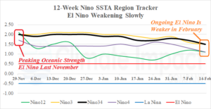
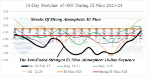
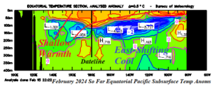
Fig. 1-3: The Nino SSTA regions and their 12-week trend (top), sequences of negative southern oscillation index identifying El Nino climate for the 2023-24 episode, and current equatorial Pacific Ocean subsurface temperature anomalies.
Summary: El Nino deceleration to neutral phase during Q2/2024 is indicated by dynamic and statistical models. Many models indicate La Nina generation will follow shortly. Based on observations cited in this report, El Nino climate could linger to mid-year with La Nina climate likely to emerge a month or 2 after oceanic La Nina (during JUL/AUG/SEP). The ENSO climate shift will produce significate climate regime change across much of the globe although specific details at this long-lead are not certain. One very likely scenario is an intense tropical cyclone season in the North Atlantic basin as La Nina climate develops mid-to-late season across another year of very warm North Atlantic sea surface temperatures. The North Atlantic tropical cyclone season is 3-4 months away but not too early to consider coastal planning for impacts of high wind, fresh and saltwater flooding.