
Northeast Pacific Marine Heat Wave Shifts To Coast; New Marine Heat Wave Off Newfoundland
07/23/2023, 3:41 pm EDTMidwest U.S. Drought Worsening Again
07/25/2023, 5:30 am EDT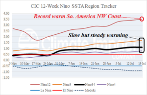
Fig. 1: The Climate Impact Company 12-week SSTA observations reveal steady strengthening El Nino.
Discussion: Last week, the Nino34 SSTA region held steady at +1.1C which represents moderate-strength oceanic El Nino (Fig. 1). Near the Dateline the Nino4 SSTA is just-above the El Nino threshold (+0.5C) warming to +0.8C last week. Other Nino SSTA regions continue to warm including the record-strength (for July) Nino12 region at +3.5C. Atmospheric El Nino has not yet formed. One indicator of an El Nino climate is a persistent negative phase of the southern oscillation index (-SOI). Although the past 10 days have produced a vigorous -SOI regime, the 15-day SOI forecast indicates a return to neutral phase (Fig. 2). Normally, a 30-60-day period of steady -SOI is required to trigger an El Nino climate. The past 120 days and 15-day forecast clearly indicate an absence of -SOI necessary to flip the climate pattern to warm-ENSO biased. The upper ocean heat signature across the equatorial Pacific is interesting as anomalous warmth providing duel for El Nino is consolidating in the eastern equatorial zones while a large are of cooling has formed near and either side of the Dateline at 150 meters (and below) depth (Fig. 3). Consolidation of warmth in the eastern equatorial Pacific subsurface is generally a sign that El Nino continues to develop.
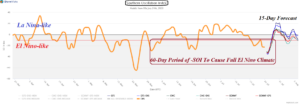
Fig. 2: The southern oscillation index is required to turn steadily negative for 30-60 days to produce an El Nino climate which is not indicated.
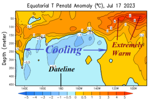
Fig. 3: The latest equatorial Pacific Ocean subsurface upper ocean heat anomalies.