Excessive Rains Continue Southeast Brazil
05/12/2024, 11:50 am EDTLighter Than Normal Windspeeds Forecast for U.S. during June/July 2024
05/16/2024, 5:40 am EDT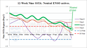
Fig. 1: The 12-week Nino SSTA monitor indicates neutral ENSO has arrived.
Discussion: Last week the Nino34 SSTA dipped below the (+0.5C) El Nino threshold. ENSO is now officially in neutral phase (Fig. 1). Only the Nino4 SSTA region (near the Dateline) is above the El Nino threshold. Normally, upper ocean heat and trend is a leading diagnostic to judge ENSO phase ahead. The East Pacific equatorial subsurface has certainly cooler and is supportive of an ENSO phase change to La Nina during the second half of 2024 (Fig. 2). The cooling is robust off the northwest coast of South America but mixed marginal cool and warm toward the Dateline. The subsurface equatorial Pacific is judged “moderately” cool and if persistent likely to bring on an oceanic La Nina slowly. The following La Nina climate may lag 3-6 weeks behind the oceanic change. Consequently, ENSO phase forecast models vary widely on the ENSO regime ahead with only 4 of 7 forecast La Nina by September and 3 of 7 in neutral phase (Fig. 3). An explanation for the weaker La Nina (forecast by ECMWF) is the influence of widespread warming of the global ocean surface away from the tropical East Pacific (Fig. 4).
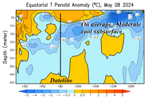
Fig. 2: The subsurface equatorial Pacific upper ocean heat anomalies identify a moderately cool signature east of Dateline supportive of La Nina ahead.
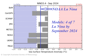
Fig. 3: The Australia Bureau of Meteorology identifies 7 leading ENSO phase forecast models and their Nino34 SSTA forecast for September 2024.
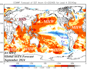
Fig. 4: The ECMWF global SSTA forecast for September 2024 identifying a weak La Nina while most of the global oceans are extremely warm.