Cause Of The Historic India Heatwave
05/05/2022, 12:21 pm EDTMay 2022 North Atlantic TC Seasonal Activity Forecast Update: La Nina Continues – Seasonal Activity Forecast Increases
05/22/2022, 11:07 am EDT
Executive summary: Historically, ENSO phase entering a 3rd consecutive summer strongly supports widespread hostile drought for the U.S. biased toward the Great Plains historically but likely tilted slightly westward this summer season due to the already strong long-term drought across the western states.
Discussion: Based on a combination of Nino34 SSTA index, southern oscillation index (SOI) and multivariate ENSO index (MEI) the La Nina 2020-22 episode began just-prior to mid-2020. All forecast models indicate La Nina will continue past mid-2022 making a 3rd-consecutive year of cold ENSO presence. A third consecutive year of La Nina occurred in 1956, 1975, 2000 and 2012. Based on these analog years, what prevailing summertime pattern followed across the U.S?
Analog years 1956, 2000 and 2012 were each the last year of a 3-year cold ENSO regime similar to 2022 expectations. The 1975 analog was part of a 5-6 year La Nina pattern not similar to 2022. Therefore analog 1 is a combination of 1956, 2000 and 2012. Analog 2 is an optimum climate normal (OCN) where the most recent events (2000 and 2012) are considered only due to climate change.
Analog 1 presents generally similar characteristics of both ENSO (Fig. 1) and mid-latitude North Pacific/North Atlantic SSTA patterns (Fig. 2-3) as identified by Pacific decadal oscillation (PDO) and Atlantic multi-decadal oscillation (AMO). The concern is the tendency of a long duration La Nina/-PDO/+AMO regime to produce vast areas of low soil moisture and drought conditions. Analog 1 identifies a widespread U.S. drought affecting the Central and South U.S. during the month of April of the analog year (Fig. 4). In April 2022, Palmer Drought Severity Index (PDSI) also reveals widespread drought biased toward the Central and West U.S. (Fig. 5).
Analog 1 reveals that the following summer produced a high-pressure ridge over the West-central U.S. (Fig. 6). To compensate for that upper ridge pattern, an equally impressive upper trough anchored over the Northeast U.S. Analog 2 has the upper ridge pattern is approximately the same location while the East U.S. trough is weaker likely due to the modern-day warmer North Atlantic influence (Fig. 7). Analog 2 is the preferred analog reference due to the occurrence in the modern-day climate pattern.
The sensible weather pattern from both analogs has important similarities. Most important is the anomalous heat and dryness in the Great Plains of increased relevance this year due to unique economic constraints. Analog 1 concentrates heat/dry risk in Nebraska to Kansas and into Texas (Fig. 8-9). Analog 2, which is the preferred historical reference for summer 2022 expectations reveals anomalous heat and dryness is most-focused on the central Great Plains to middle Continental Divide (Fig. 10-11).
Short-term soil moisture observations in the Great Plains reveal torrid drought in Texas and the west/southwest Great Plains (Fig. 12). The May (so far) soil moisture change is wetter across the eastern Great Plains to the Upper Midwest (Fig. 13). However, given the historical precedent, the likelihood of regenerating anomalous heat and dryness justifies expanding Great Plains drought for summer 2022 ahead. The upper-level high-pressure ridge causing super-hot weather across Texas and vicinity continues into early summer and then lifts northward mid-summer pushed by a stronger than normal South U.S. monsoon pattern.
Conclusion: A 3rd consecutive La Nina summer identifies a hostile summer drought scenario historically most-focused on the Great Plains. Due to the presence of established drought across most of the West U.S., the summer 2022 drought pattern is likely to be most-focused on the West-central U.S. with influence almost certainly extending to the U.S. West Coast and toward the Mississippi River. Short-term wetter patterns in parts of the Great Plains are expected to reverse during meteorological summer.
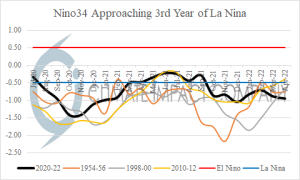
Fig. 1: Analog years of La Nina entering a 3rd consecutive year for the Nino34 SSTA index.
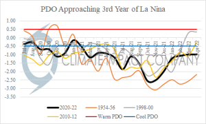
Fig. 2: Analog years of Pacific decadal oscillation entering a 3rd consecutive year for the Nino34 SSTA index.
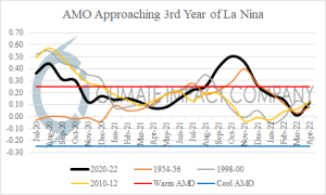
Fig. 3: Analog years of Atlantic multi-decadal oscillation entering a 3rd consecutive year for the Nino34 SSTA index.
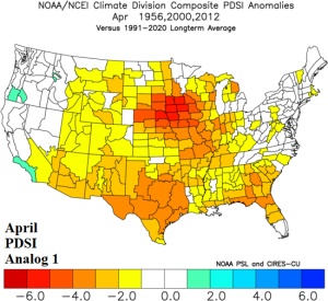
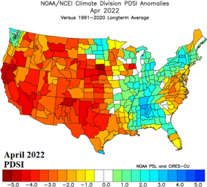
Fig. 4-5: During April as the second of a 3-year La Nina ends, the prevailing U.S. soil moisture regime as measured by Palmer Drought Severity Index (PDSI).
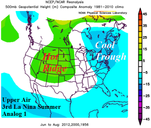
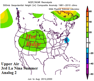
Fig. 6-7: The La Nina 3rd year summertime upper air pattern for the U.S. for analog 1 and analog 2.
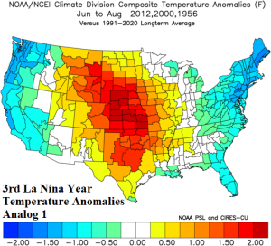
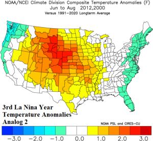
Fig. 8-9: The La Nina 3rd year summertime temperature anomaly pattern for the U.S. for analog 1 and analog 2.
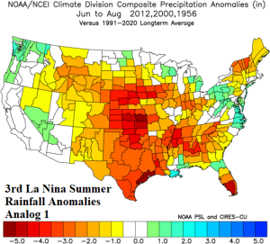
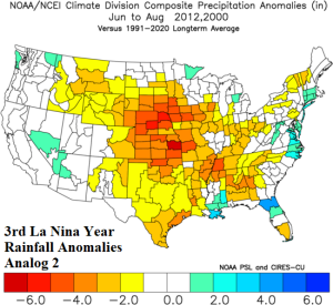
Fig. 10-11: The La Nina 3rd year summertime precipitation anomaly pattern for the U.S. for analog 1 and analog 2.


Fig. 12-13: Daily U.S. soil moisture anomaly rankings and the May (so far) soil moisture change.