Over-achieving Solar Cycle 25 Continues!
07/13/2023, 9:42 am EDTU.S. Heatwave to Expand to Midwest and Mid-Atlantic U.S. and Midwest Drought to Re-intensify
07/19/2023, 4:59 am EDT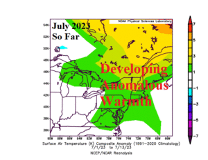
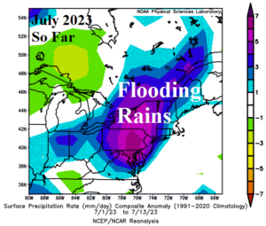
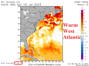
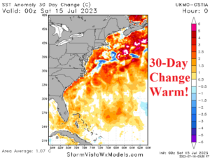
Fig. 1-4: The Northeast U.S. temperature and precipitation anomalies for July 2023 so far and the western North Atlantic SSTA plus 30-day change.
Discussion: After a relatively dry and cool spring in the Northeast U.S. Corridor somewhat related to a large area of cooler than normal ocean water off the coast, the weather pattern has changed dramatically in this sector. During July so far, the Northeast U.S. has shifted 1-3C warmer than normal (Fig. 1) while flooding rainfall events have emerged (Fig. 2). The anomalous warmth is biased (and made more uncomfortable) by high humidity. The rainfall events are producing historical flooding in Vermont and widening toward central New England to eastern Pennsylvania. Not surprisingly, the prevailing SSTA regime of the western Atlantic has warmed dramatically now averaging +1.07C (Fig. 3) with a 30-day warm-up of +1.24C (Fig. 4). The Gulf Stream managed to punch through the North Atlantic warm hole (NAWH) and warm the western North Atlantic as calendar summer began. The warming western North Atlantic will continue well into tropical cyclone season increasing concern of systems approaching the coast maintaining (or increasing) intensity. For now, the warming West Atlantic SSTA maintains the wet pattern in the Northeast including a major flooding event today (Fig. 5) and staying wet through the end of July with the latest GFS 15-day forecast (Fig. 6).
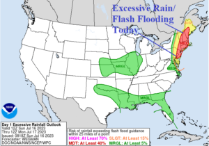
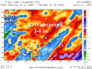
Fig. 5-6: The NOAA/WPC excessive rainfall/flash flood risk area in the Northeast today and the GFS 15-day rainfall amount forecast for the Northeast States.