Wetter Central U.S. Ahead but Does That Rain Benefit Mississippi River?
09/13/2023, 9:06 am EDTDrought Concerns for Brazil and Australia for Summer 2023-24 Emerging; Australia Heat Strengthens!
09/18/2023, 5:15 am EDTHighlight: Eastern New England battered by backside of Lee, 12Z GFS trend is cooler West and warmer East, and heavy rains are ahead for Western Europe.
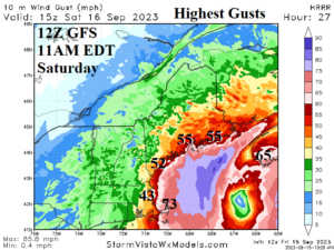
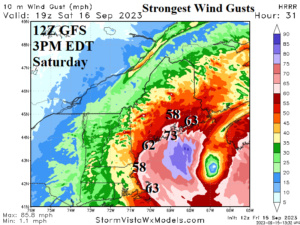
Fig. 1-2: The latest HRRR model projects maximum peak wind gusts for tomorrow associated with Lee. The strongest gusts along the New England coast are mid-afternoon tomorrow.
Discussion: Large veil of high wind shifts to the west side of Lee as the storm becomes extra-tropical. Consequently, strong tropical storm force to minimal hurricane force gusts is likely for eastern Massachusetts and particularly Cape Cod to coastal New Hampshire and well inland for Maine (Fig. 1-2). Consistent wind gusts >50 mph will knockout power. Power outages will be widespread along the coast and well into New Brunswick/Western Nova Scotia. A storm surge of up to 3 feet is expected and is generated quickly ahead of the approaching storm.
Tropical Depression 15 has formed in the east-central tropics and is forecast to become a major hurricane (Nigel) in 4-5 days while heading toward Bermuda (Fig. 3). Most models agree that Nigel will stay to the right of Lee’s track later next week.
The remains of Lee, Margot, and eventually Nigel are heading to Europe. The 10-day rainfall forecast indicates up to 6 in. of rain in U.K. (Fig. 4).
At midday, the 12Z GFS averaged cooler in the West and warmer in the East (away from the coast) during the medium range (Fig. 5-6).
Low water will continue for the central and south-central Mississippi River in the latest 10-day forecast.
The U.S. population weight CDD forecast is generally above normal through the remainder of September and trends warmer for Sep. 29-Oct. 5 (Table 1). The gas population weight HDD forecast for Sep. 29-Oct. 5 is 24 HDD which is about 10 below normal.
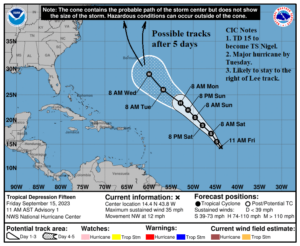
Fig. 3: The initial 5-day forecast track for TD 15 soon to be Nigel from NOAA/NHC.
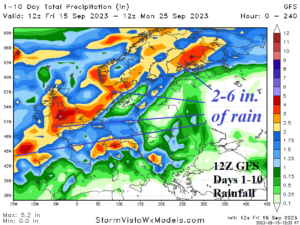
Fig. 4: The 12Z GFS 10-day rainfall forecast for Europe.
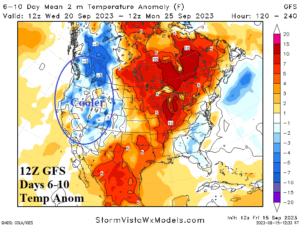
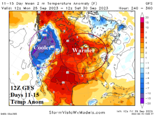
Fig. 5-6: The 12Z GFS temperature anomaly forecast for the medium range across the U.S.
| Dates | CDD Forecast | 12-Hr Change | 24-Hr Change | 30-Year NML | 10-Year NML |
| Sep. 15-21
| 42.4 | -0.2 | -4.2 | 41.3 | 48.3 |
| Sep. 22-28
| 40.3 | -7.6 | +0.4 | 32.6 | 38.9 |
| Sep. 29- Oct. 5
| 36.6 | +4.3 | +6.1 | 25.3 | 30.7 |
Table 1: The 12Z GFS U.S. population weight CDD forecast compared to 12 and 24 hours ago.