Classic Modern-day Cold Season 2023-24 HDD Curve
04/08/2024, 5:04 am EDTRecent Precipitation Forecast Verification days 11-15 U.S. AG Belt and Europe
04/11/2024, 9:56 am EDT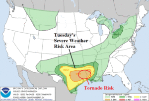
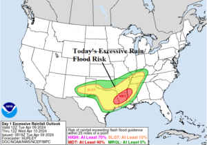
Fig. 1-2: Tuesday’s severe weather and excessive rain risk areas.
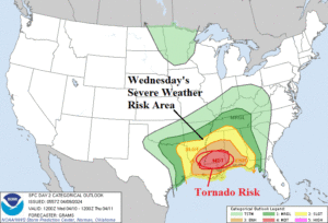
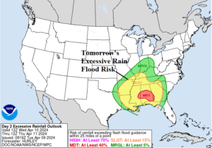
Fig. 3-4: Wednesday’s severe weather and excessive rain risk areas.
Discussion: By this afternoon, severe thunderstorms align across central Texas eastward to Louisiana with tornado risk for late day and evening in northeast Texas and northwest Louisiana (Fig. 1). Flash flooding is already taking place in northern Louisiana and will worsen today (Fig. 2). On Wednesday, the peak intensity of this storm is realized. A large mass of severe thunderstorms is projected across much of the Northern Gulf States with tornado risk from Louisiana to Alabama (Fig. 3). Excessive rain and attendant flooding strike the entire Southeast U.S. centered on Alabama (Fig. 4). On Thursday, the severe weather risk remains although not as intense (Fig. 5). As the storm moves into the East, a southerly gale develops on the East Coast causing coastal flooding to already higher than normal sea level. Excessive rainfall stretches along the Appalachian Spine on Thursday (Fig. 6). A windswept rain moves across the Northeast on Friday. Expect a widening flood risk area over the next 2-3 days (Fig. 7) including coastal communities on the Atlantic Seaboard.
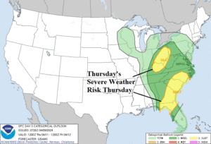
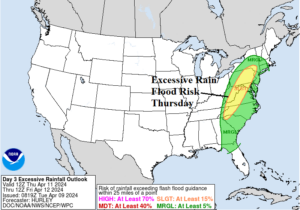
Fig. 5-6: Thursday’s severe weather and excessive rain risk areas.
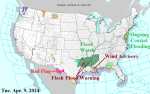
Fig. 7: Latest NOAA/NWS weather watch, warning, and advisory areas.
The U.S. gas population weight HDD forecast continues to yield below normal late season heating demand and a warmer change from48 hours ago (Fig. 8).
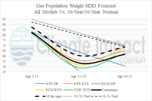
Fig. 8: The U.S. gas population weight HDD forecast utilizing all models, their consensus, and comparing with 48 hours ago and the 10-year/30-year normal.