Extraordinarily Warm (and Dry) U.S. Medium-range Forecasts
08/30/2023, 6:07 am EDTVery Dry Month of August in Australia
09/04/2023, 9:25 am EDT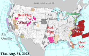
Fig. 1: Latest NOAA/NWS weather watch, warning, and advisory areas.
Discussion: Idalia is rapidly departing the Mid-Atlantic Coast (Fig. 1). In Florida, in the wake of a warm atmosphere following departing Idalia, a Heat Advisory is issued for east and south sections. Red Flag Warnings are issued for East Texas/Louisiana and parts of the Intermountain West. Given a dry pattern ahead for the Central and East U.S. (and parts of the West) expect more Red Flag Warnings in early September. Red Flag Warnings are issued for the central and western (leeward) Hawaiian Islands.
The NOAA/WPC 7-day quantitative precipitation forecast (QPF) indicates Idalia moving off the Mid-Atlantic Coast today while a tropical rain evolves along the Gulf Coast into the weekend (Fig. 2). Fortunately, the tropical rains organize to close to the coast for a tropical system to develop. The wet monsoon returns to the Interior West and a showery regime persists in the Northwest. The next 7 days produce little or no rain in the Great Plains to Texas to the Northeast U.S.
The U.S. population weight CDD forecast identifies a steadily increasing cooling demand through early September (Fig. 3).
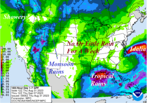
Fig. 2: NOAA/WPC 7-day quantitative precipitation forecast for the U.S.
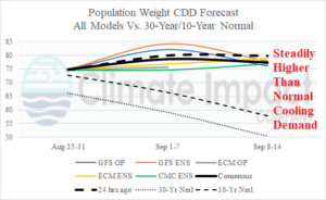
Fig. 3: U.S. population weight CDD through early September utilizing all models, their consensus and comparison with 24 hours ago plus the 10-year/30-year normal.