Kansas Dryness Expanding and Intensifying
05/15/2020, 8:58 am EDT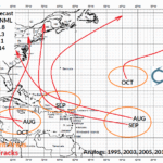
NOAA 2020 North Atlantic Hurricane Outlook
05/21/2020, 12:00 pm EDTHighlight: Warm sea surface temperature anomalies (SSTA) provide the heat to cause tropical cyclones to flourish!

Fig. 1: The northern hemisphere tropical cyclone season starts earlier than normal.
Discussion: Already three tropical cyclones have formed in the northern hemisphere before the official June 1 start to the tropical cyclone season (Fig. 1). Warmer-than-normal ocean water played a key role in leading to the formation of Arthur east of Florida, rapid intensification of Vongfong to a category 3 tropical cyclone before striking the Philippines and emergence of a category 5 tropical cyclone (Amphan) in the Bay of Bengal.
The NCEP CFS V2 global SSTA forecast for AUG/SEP/OCT 2020, the peak of tropical cyclone season indicates extremely warm anomalies in the West Pacific tropics and almost as impressive warmth in the subtropical North Atlantic basin (Fig. 2). Also note the La Nina in the equatorial East Pacific. These conditions (warm surface water in western ocean basins and influence of La Nina on climate) support above normal activity and intensity of typhoons/hurricanes approaching the East Asian Coast and Gulf of Mexico Coast/Atlantic Seaboard during this 90-day period.

Fig. 2: The NCEP CFS V2 global SSTA forecast indicates very warm waters for tropical cyclones during peak of season (AUG/SEP/OCT).