Longterm Brazil Rainfall Climate Review
10/12/2023, 3:18 pm EDTKey Climate Diagnostics: -SOI Weakens, Surging Snow Cover, NEP23A Backs Off Coast, and +IOD Strengthens
10/31/2023, 3:37 pm EDTHighlight: Central Brazil drought ahead. Northern Argentina drought should ease.
Executive Summary: The Climate Impact Company month 1-3 ahead climate outlook valid for November 2023 to January 2024 is updated. A very interesting forecast featuring two climate patterns for NOV/DEC: Dry and hot for Central and East Brazil while Northern Argentina to Southeast Brazil are wet. Expect harsh drought to emerge and intensify in Central Brazil while the Northern Argentina drought is easing. In January, wet weather shifts north and eases drought to the east of Mato Grosso while Central Brazil drought is likely to continue.
Climate: Since 2016 (except 2019), an intense upper-level low has occupied the southeast South Pacific from the Amundsen Sea off the coast of Antarctica toward southwest South America (Fig. 1). The semi-persistent upper low may be related to increased runoff of snow and ice melt causing a stratified cool pool of water near and north/northeast of the Amundsen Sea cooling the air aloft to cause the semi-permanent trough. A similar process has generated during the past decade to the south of Greenland and is referred to by climate scientists as the North Atlantic warm hole (NAWH). Climate Impact Company is recognizing the Amundsen Sea upper trough and applying presence to climate forecasts.
However, during AUG/SEP/OCT 2023, the Amundsen Sea low has disappeared and been replaced by an upper ridge (Fig. 2). The presence of the Amundsen Sea low (since 2016) and isolated disruption (2019 and 2023) seems to be independent of ENSO phase. The effect of this regime on Brazil rainfall for AUG/SEP/OCT is generally wetter than normal. However, during the past 3 months, Central Brazil is notably dry while rainfall has consolidated mostly in East/Southeast Brazil.
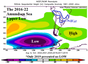

Fig. 1-2: The presence of the Amundsen Sea low from 2016 to 2022 (except 2019) and the reversal in this pattern of the past 2.5 months in 2023.
Going forward, the leading mode of climate variability on South America climate is El Nino and positive phase Indian Ocean dipole (+IOD). El Nino and +IOD occurring at the same time are common, the east Pacific SSTA warms, the West Pacific/Indonesia SSTA cools, and the western Indian Ocean SSTA warms. However, this year the ENSO climate pattern as defined by multivariate ENSO index (MEI) is not indicating a strong El Nino. The SSTA patterns in the eastern equatorial East Pacific indicate robust El Nino second only to the 1997 and 2015 record-tying El Nino strength (events). However, the equally robust MEI of +2.3 and +2.1 respectively of the two intense El Nino events of 1997 and 2015 are not well-matched with the paltry +0.6 MEI present now. The presence of marine heat waves (MHW) and warm holes in the non-tropical region is causing this weaker El Nino climate signal. The Amundsen Sea trough (and shift to a ridge in 2023) is (in-part) causal of the weaker El Nino climate.
Methodology: The Climate Impact Company month 1-3 ahead climate forecast is based on a simple analog of past El Nino/+IOD regimes coupled with a reversal in the recent Amundsen Sea upper air pattern and valid for NOV-23 to JAN-24.
November 2023: The upper air projection for November features an amplified upper ridge over Brazil centered on the Southeast Coast. The upper troughs are on either side of the southern half of South America coasts. The sensible weather pattern is hot and dry across Central Brazil to the East Coast and wet climate for Eastern Paraguay across Southeast Brazil. In Argentina, a temperate and near normal rainfall pattern is expected. The forecast has similarities to the outlook issued last month.
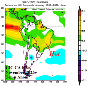
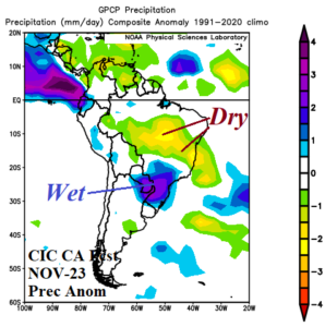
Fig. 3-4: Climate Impact Company November 2023 constructed analog temperature and precipitation anomaly forecast for South America.
December 2023: The upper air pattern maintains the Brazil ridge during early meteorological summer and amplifies intensity on the Southeast Brazil coast. A strong upper trough extends across Southern Argentina. Wet climate in Southeast Brazil is expanding southwestward well into Argentina to begin the meteorological summer season. A quasi-persistent frontal boundary between the upper trough in southern South America and the Brazil ridge causes the rainfall. In Central to East Coastal Brazil dryness and anomalous heat continue as drought continues to strengthen.
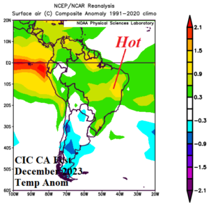
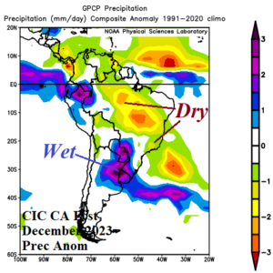
Fig. 5-6: Climate Impact Company December 2023 constructed analog temperature and precipitation anomaly forecast for South America.
January 2024: The upper ridge over Brazil is weaker while an upper trough east of Argentina is stronger during mid-summer. The outlook for mid-summer indicates a pattern change for East Brazil. The tail end of the upper trough east of Argentina extends northwestward and interacts with the subtropical pattern to produce above normal rainfall for areas mainly just east of Mato Grosso and southwestward to Paraguay and Northern Argentina. The Southeast Coast of Brazil shifts drier. Most of Brazil remains hotter than normal for January 2024.
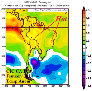
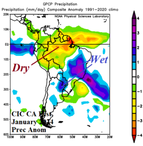
Fig. 7-8: Climate Impact Company January 2024 constructed analog temperature and precipitation anomaly forecast for South America.