Looks Warmer Than Normal for the High Demand PJM Sector for Winter Ahead
10/05/2023, 8:02 am EDTSEP and JUL/AUG/SEP 2023 U.S. Climate Highlights: Gulf States Torrid Heat and Drought; Soaking Wet New England
10/10/2023, 1:59 pm EDTExecutive summary: The JUL/AUG multivariate ENSO index (MEI) failed to indicate evolution of an El Nino climate despite the robust oceanic El Nino presence across the equatorial East Pacific. Consequently, adjustments of the ENSO 2023-24 forecast considering MEI indicate that despite a robust warm equatorial East Pacific SSTA regime continuing to strengthen during Q4/2023, the attendant El Nino climate is likely moderate.
Discussion: El Nino 2023-24 is weird. First, despite a robust (+1.5C) Nino34 SSTA in September which held steady during the past week, an El Nino climate is barely alive after onset during recent weeks based on the multivariate ENSO index (MEI) which is +0.6 (just above the +0.5 El Nino threshold). Second, the convection patterns, vertical velocity, and mid-troposphere relative humidity (RH) patterns are not in-line with historical El Nino. As an example, during El Nino mid-troposphere RH is usually soaking wet across the eastern equatorial tropics and to compensate, drier than normal in the West Pacific tropics. This year, RH is soaking wet across Indonesia to the Dateline which is usually wetter than normal during El Nino (Fig. 1). Third, warming of the subsurface equatorial Pacific has not consolidated in the East Pacific, typical of El Nino episodes. Instead, anomalous warm water in the equatorial Pacific stretches the length of the Pacific Ocean and is diminishing in recent weeks (Fig. 2). Climate diagnostics are mixed on El Nino and the overall tendency is slightly weaker intensity heading into Q4/2023.
Using MEI to produce a constructed analog projection of ENSO phase through 2024 yields peak strength in December, weakening during late winter/early spring, and shifting to La Nina before mid-2024 (Fig. 3). The conventional Nino34 SSTA constructed analog is stronger with El Nino although with same peak intensity time and followed by a flip to La Nina by mid-2024 (Fig. 4). The International Research Institute (IRI) for Climate and Society has collected all dynamic and statistical ENSO phase forecasts utilizing the Nino34 SSTA. Revealed is a wide disparity in El Nino intensity but agreeable to a late year peak followed by deceleration toward and possibly into La Nina later next year (Fig. 5).
One theory explaining the weaker climate pattern as compared to the oceanic signature, is the broad anomalous warmth of the global oceans outside the tropics. Additionally, the warmer mid-latitude tropical oceans and the attendant effect on climate may shift typical El Nino climate for Q4/2023 and Q1/2024. As an example, warming in the Northeast Pacific is well-correlated with above normal 500 MB heights or high-pressure ridging. The presence of the ridge in this region would weaken or nullify El Nino’s typical wet influence on California wet El Nino winter.
Conclusion: El Nino 2023-24 has a split personality indicating a weak influence on climate while the oceanic diagnostics are quite strong. Forecasts are agreeable to an El Nino peak late this year followed by steady weakening to neutral ENSO and possibly La Nina just-after mid-2024. The weaker El Nino climate is likely related to the influence on climate by warm SSTA throughout the mid-latitude oceans. Consequently, some El Nino climate signatures for OCT through MAR may alter.
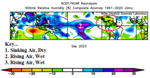
Fig. 1: In September 2023, despite a robust oceanic El Nino signal, wet relative humidity appeared across Indonesia to the Dateline which is normally drier than normal during El Nino.
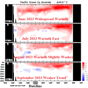
Fig. 2: Upper ocean heat is weakening and not consolidated in the East Pacific, typical of an El Nino.
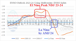
Fig. 3: ENSO analog forecast through 2024 using multivariate ENSO index.
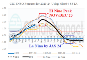
Fig. 4: ENSO analog forecast through 2024 using Nino34 SSTA index.
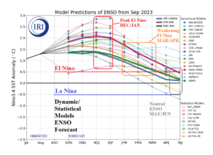
Fig. 5: A collection of dynamic and statistical ENSO phase forecast models by the International Research Institute (IRI) for Climate and Society using the Nino34 SSTA index.