Reworking North Atlantic Basin Seasonal Tropical Cyclone Climatology
03/27/2024, 10:33 am EDTBrazil and (More) Europe Rains Ahead!
03/31/2024, 10:36 am EDTExecutive summary: The Climate Impact Company (CIC) 2024 North Atlantic basin tropical cyclone (TC) season forecast projects 20 tropical storms, 10 hurricanes, and 5 intense hurricanes. The accumulative cyclone energy (ACE) index forecast is 187. The activity forecast is somewhat higher than normal. The forecast is based on strongly favorable environmental conditions including a low shear upper-level environment due to the evolution of La Nina and plentiful upper ocean heat in the deep tropics and subtropics as identified by the tropical North Atlantic (TNA) index. The projected hurricane tracks for the 2024 season based on the CIC constructed analog and climatology is dangerous featuring potential for 5 land-falling systems. Forecasts issued by Colorado State University on April 4 and Tropical Storm Risk/U.K. on April 8 are likely as active or slightly more active than the CIC projection. An extremely dangerous TC season ahead is expected.
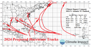
Fig. 1: The Climate Impact Company seasonal activity forecast and projected hurricane tracks for the 2024 North Atlantic basin TC season.
Climatology: CIC has updated the tropical cyclone (TC) climatology according to leading predictors: El Nino southern oscillation (ENSO) and tropical North Atlantic (TNA) index. TC activity is regulated primarily by upper-level windshear, controlled by the ENSO regime and upper ocean heat in the tropics best identified using the TNA index. Interestingly, the updated climatology indicates moderate La Nina favors the most active TC seasons, not strong La Nina as commonly believed (Fig. 2). Unfortunately, the ENSO prediction for 2024 during the TC season is a transition into moderate La Nina. Predictably, when the TNA index is warmest, seasonal TC activity is highest (Fig. 3). The TNA index has maintained a record warm signature since last year with expectations of continued historical warmth during the 2024 season. The ENSO and TNA outlooks are each highly supportive of a very active tropical cyclone season.
Accumulated cyclone energy (ACE) index helps to identify the “activeness” of the season. ACE index climatology has also been updated according to ENSO and TNA phase and intensity. Similar with numbers of tropical cyclones, seasonal ACE index is highest during moderate strength La Nina (Fig. 4) and strongest warm phase TNA index (Fig. 5).

Fig. 2: Climate Impact Company climatology of North Atlantic basin tropical cyclone activity since 1950 according to ENSO phase and intensity.
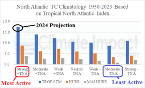
Fig. 3: Climate Impact Company climatology of North Atlantic basin tropical cyclone activity since 1950 according to TNA phase and intensity.
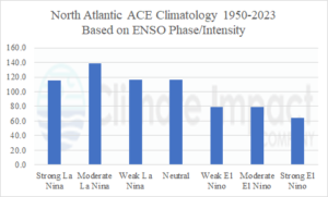
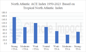
Fig. 4-5: Climate Impact Company ACE climatology based on ENSO and TNA phase/intensity.
Climate forecast: The ENSO and TNA forecast are the primary contributors to the seasonal activity forecast. ENSO is currently in a weakening El Nino pattern. However, rapid loss of upper ocean heat during recent weeks in the equatorial Pacific Ocean (Fig. 6) foreshadows an ENSO phase change on the way. The CIC constructed analog forecast projects La Nina prior to mid-year and moderate La Nina intensity for late in the tropical cyclone season (Fig. 7). Current global SSTA reveals the lingering El Nino and strong warming of the tropical North Atlantic basin (Fig. 8). The North America multi-modal ensemble (NMME) AUG/SEP/OCT 2024 forecast projects moderate La Nina and continued very warm tropics/subtropics in the North Atlantic (Fig. 9) each extremely supportive of buoyant TC activity in 2024.
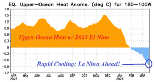
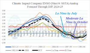
Fig. 6-7: Upper ocean heat across the equatorial Pacific during the past 12 months and Climate Impact Company constructed analog ENSO phase forecast.
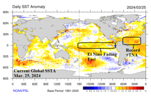
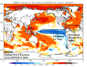
Fig. 8-9: Current global SSTA analysis identifying the fading El Nino and record warm TNA regime and the NMME global SSTA forecast for AUG/SEP/OCT 2024 depicting La Nina and continued warm TNA.
The analog forecast: The Climate Impact Company constructed-analog (CIC-CA) forecast of North Atlantic basin tropical cyclone activity is based on ENSO and TNA years similar with projections for the 2024 season. Fortunately, the selected years are very straightforward and include 2016, 2010, 1998, and 1995. Each analog year produced an El Nino to La Nina transition with strong warm sea surface temperature anomalies (SSTA) in the North Atlantic tropics similar with the 2024 expectations. The correction bias is based on 1999-2023 CIC April forecasts and verification error bias (Fig. 10) which is +2.58 for tropical storms, +0.375 for both hurricanes and intense hurricanes, and +8.1 for ACE index. The bias values are positive due to the warming of the North Atlantic causing a tendency for seasonal forecasts to underperform (slightly). The bias is added to the constructed analog values to create the final forecast (Table 1).
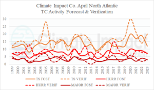
Fig. 10: The Climate Impact Company April seasonal forecasts for North Atlantic tropical cyclone activity and observations for 1999-2023.
| Tropical Storms | Hurricanes | Intense Hurricanes | ACE Index | |
| 2016 | 15 | 7 | 4 | 141 |
| 2010 | 19 | 12 | 5 | 166 |
| 1998 | 14 | 10 | 3 | 182 |
| 1995 | 19 | 11 | 5 | 227 |
| Average | 17.0 | 10.0 | 4.25 | 179.0 |
| Correction | +2.58 | +0.375 | +0.375 | +8.1 |
| Forecast | 20 | 10 | 5 | 187 |
| Last Year | 20 | 7 | 3 | 146 |
| 30-Year NML | 130.4 | 15.5 | 7.5 | 3.4 |
| 15-Year NML | 132.5 | 17.7 | 7.9 | 3.5 |
| 50-Year NML | 107.0 | 13.0 | 6.6 | 2.7 |
Table 1: The CIC-CA North Atlantic basin 2024 seasonal tropical cyclone activity forecast.
Monthly formation areas and projected tracks forecast: From a climate perspective, tropical cyclone activity is present in areas where the lower mid-troposphere is wet. To identify these zones, research has shown that relative humidity (RH) at 600 MB is an appropriate diagnostic. Using the analog years CIC identifies where RH is likely most buoyant on the monthly basis from June through October 2024. Combining implications of the RH pattern with climatology, the most likely tropical cyclone tracks are annotated on each monthly chart.
June/July 2024: During June, the CIC-CA forecast projects anomalous 600 MB RH in the Caribbean Sea strongly supporting the presence of an early season TC (Fig. 11). Interestingly, the location is east of where most TC’s form during early season. The Caribbean TC is likely to turn north and northeast from the development area southwest of Hispaniola. In July, the 600 MB RH anomalies indicate large areas of a wet mid-troposphere across the Caribbean Sea and southern Gulf of Mexico (Fig. 12). The high RH in these areas this early in the season is unusual. TC’s are likely to generate in the Southwest Caribbean Sea and/or Southwest Gulf of Mexico and arc northwestward toward the Yucatan Peninsula and Old Mexico. An early season hurricane in this zone is possible. There is also risk that TC activity forming in the Southwest Caribbean Sea could drift northward and strike Cuba. Another zone of development is in the central tropical North Atlantic. TC’s forming in this area are likely to drift westward, possibly reaching Florida.
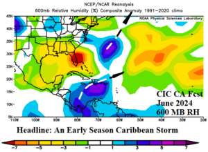
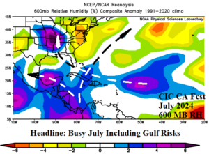
Fig. 11-12: The CIC-CA 600 MB RH forecast for June and July 2024 used to determine where tropical cyclones will develop and track.
August/September 2024: The deep tropics look spectacularly active in August (Fig. 13). TC formation areas are projected across the Southwest Caribbean Sea and Southwest Gulf of Mexico, and subtropical/tropical North Atlantic east and northeast of the Caribbean Sea. The wet 600 MB RH projections indicate up to 5 popular TC tracks during late meteorological summer including Texas and possibly Florida as common U.S. landfall zones. Most of the August activity stays out-to-sea. The September projection identifies the month of the TC season when the U.S. coast is most at risk (Fig. 14). Texas is targeted (again) plus the East Coast. The Canadian Maritimes are susceptible to multiple coastal strikes.
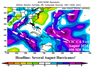
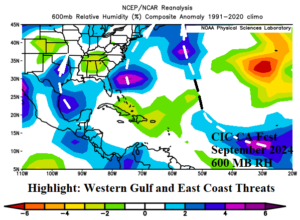
Fig. 13-14: The CIC-CA 600 MB RH forecast for August and September 2024 used to determine where tropical cyclones will develop and track.
October 2024: The 600 MB RH is minimal across the eastern half of the U.S. implying a dry climate and low risk of impacts by TC’s on coastal areas (Fig. 15). Late season TC activity is likely in the Caribbean Sea and outer North Atlantic tropics. However, forecast tracks keep TC’s away from the U.S. although the Caribbean Islands are at high risk.
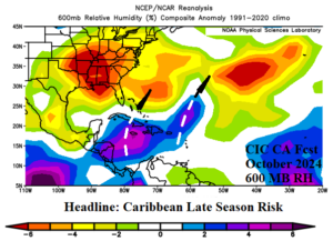
Fig. 15: The CIC-CA 600 MB RH forecast for October 2024 used to determine where tropical cyclones will develop and track.
FINAL 2024 forecast: The FINAL projected hurricane tracks for the 2024 season are based on the RH forecasts previously shown, average tracks from the analog years, and climatology. The projected 10 hurricane tracks for the 2024 season including the most likely month of occurrence are indicated in Fig. 16. The outlook indicates potential for 5 hurricane strikes to the U.S. Coast including 2 strikes in Texas and Florida and another system into the Carolinas. U.S. coastal strikes from hurricanes have increased in recent years averaging near 3 for 2016-2021 including 6 in 2020. The risk to Texas is projected in July and August while a second July hurricane crosses Florida into the northeast Gulf and onto Mississippi. Another hurricane strikes the GA/FL state line in September. A 5th threat is indicated for the North Carolina coastal region in September. Primary tropical cyclone generation areas in the west/southwest Caribbean Sea and outer North Atlantic basin are all active this season.
Fig. 16: Combining the CIC-CA 600 MB anomaly forecast, analog tracks, and climatology, the FINAL hurricane track projection is indicated.