Central/East-central Brazil Strengthening Drought Watch Initiated
11/01/2023, 5:37 pm EDTNext 10 (Hot and Dry) Days Important Determining Central Brazil Summer Drought Risk
11/09/2023, 5:09 am ESTExecutive Summary: The Climate Impact Company month 1-4 ahead outlook for the winter 2023-24 season is adjusted less warm due to a potential cold January. The forecast features above normal precipitation for Western Europe and West/Northwest Russia where above normal snowfall is likely.
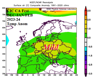
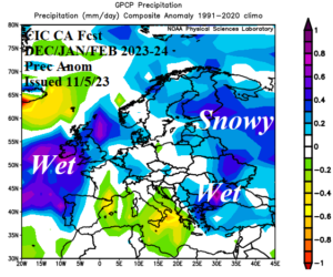
Fig. 1-2: The Climate Impact Company constructed analog meteorological winter 2023-24 outlook for Europe and Western Russia.
Climate discussion: The Europe/Western Russia winter 2023-24 climate forecast is based on North Atlantic SSTA, Norwegian Sea SSTA, the Indian Ocean dipole (IOD), and El Nino southern oscillation (ENSO). Added are early season snow cover and trend.
We begin with the recently evolved North Atlantic warm hole (NAWH). During the past decade, a semi-permanent low-pressure area has formed over a cool pool of SST located south of Greenland. The cool pool tendency is to peak in strength during the early warm season (Fig. 3-4) although the influence on climate can be year-round and certainly is evident in the 10-year climatology (Fig. 5). The influence of this pattern on winter climate in Europe strongly favors anomalous warmth (Fig. 6) whereas the previous decade when NAWH was not present was generally cold (Fig. 7). The NAWH pattern is helping to cause stormy Western Europe and warm Eastern Europe/Western Russia climate so far in the early cool season (Fig. 8-9). Global SSTA forecasts maintain the presence of the NAWH pattern through the winter 2023-24 season (Fig. 10).
During recent decades the ocean surface north of Eurasia has featured open water well into the winter season. Initially, the open water was (in-part) a catalyst to warming the atmosphere aloft in the northern latitudes sometimes leading to high-pressure blocking pattern over Greenland which forced a cold trough into Europe. This pattern was notable in the late 1990’s through the first decade of this century (Fig. 11). However, this effect has been weakened and possibly replaced by the NAWH regime during the past 10+ years as Europe winter climate has flipped warmer (Fig. 12). Nevertheless, monitoring SSTA in the Norwegian Sea remains important to identifying potential for high latitude blocking high pressure patterns which lead to cold weather set-ups for Europe (and eastern North America).
ENSO is an equatorial Pacific phenomenon. However, ENSO affects the entire global climate system therefore Europe and Western Russia despite the distance between each region. Generally, El Nino leads to increased Pacific westerlies in the middle latitudes that extend across North America and frequently reach Europe having a mild maritime influence on climate. Russia is less affected by this persistence. Oceanic El Nino is strong and will persist through the winter season peaking during January (Fig. 13).
Normally, the Indian Ocean dipole (IOD) is not discussed as a climate influence on Europe/Western Russia winter climate. However, the +IOD pattern present now in the tropical Indian Ocean is quite strong, affecting tropical convection (similar too El Nino) and producing poleward influence on Eurasia climate. As +IOD has strengthened during the past 30 days the prevailing Eurasia upper air pattern has featured THIS and THAT (Fig. 14) and this influence may last well into the winter season until weakening during late winter.
Early season snow cover patterns are established. So far, above normal snow cover is dominant in Canada and parts of Central to Northeast Asia (Fig. 15). However, snow cover is shifting below normal in Northwest Russia and previous above normal snow cover in Northern Europe is diminishing. Snow cover will bias climate cold while absence of snow cover has the opposite effect.
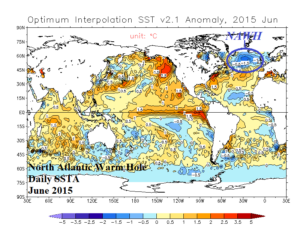
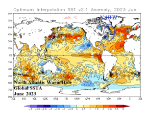
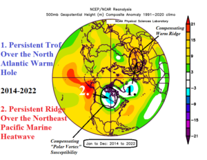
Fig. 3-5: During the past decade, evolution of the North Atlantic warm hole south of Greenland persists sometimes most notable in June. In 2023, the NAWH shifted westward to the Northeast U.S. Coast for the first time in the 10-year sequence. The northern hemisphere upper air pattern for the past 10 years identifies the upper trough associated with the NAWH SSTA pattern.
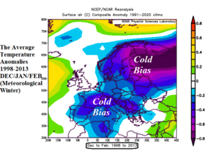
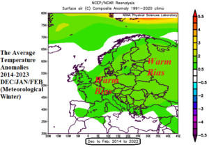
Fig. 6-7: The 1998-2013 chilly winter climatology across Europe flips warmer during the past 10 years. The tendency for high latitude blocking associated with warm SSTA north of Europe lead to the cold bias in 1998-2013. Since 2013, emergence of the NAWH pattern is causal to a warmer ridge pattern in Europe during winter.
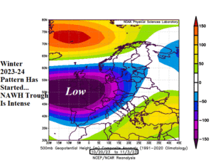
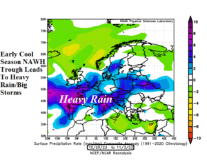
Fig. 8-9: Climate regimes such as Madden Julian oscillation (MJO) have helped re-invigorated the NAWH trough as the cool season starts very storms into Europe.
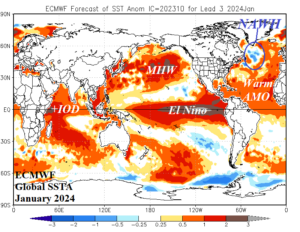
Fig. 10: ECMWF global SSTA forecast for January 2024 identifying the NAWH pattern in the North Atlantic plus El Nino, +IOD, and the North Pacific MHW regime.
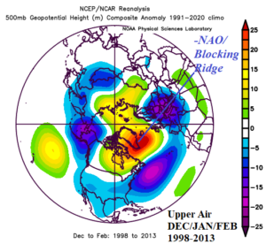
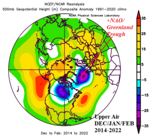
Fig. 11-12: Upper air regimes for wintertime in 1998-2013 when warm waters north of Europe were well-correlated to a blocking ridge over Greenland and the chance since that time likely related to the NAWH pattern which reversed the Greenland high pressure block to a low-pressure area.
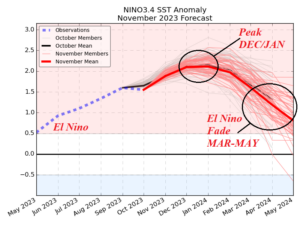
Fig. 13: The ECMWF Nino34 SSTA forecast to determine ENSO phase and strength through May of 2024.
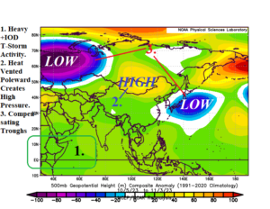
Fig. 14: Upper air pattern across Eurasia past 30 days related to a strengthening +IOD pattern in the tropical Indian Ocean.
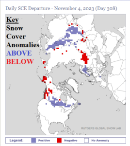
Fig. 15: Northern hemisphere snow cover anomalies for Nov. 4, 2023, according to Rutgers Global Snow Lab.
Forecast methodology: The Climate Impact Company constructed analog (CIC-CA) climate forecast is based on upper air patterns (and their sensible weather) caused by the SSTA regimes described and projected forward several months to generate the Europe/Western Russia winter outlook.
December 2023: The updated winter outlook identifies changes for early meteorological winter. A chilly upper trough evolves over West-Central Russia while the NAWH trough over Western Europe in November shifts slightly offshore. In-between each trough, an upper ridge yields a mild climate for most of Europe in December. The forecast is not as warm as previously indicated as colder air mass in Russia may extend westward to Northern Europe at times through early winter. The southern 2/3 of Europe are mild in December while the storm track could be impressive into U.K. and extends eastward into Eastern Europe and the Baltic States. Above normal snowfall is likely across Southwest Russia.
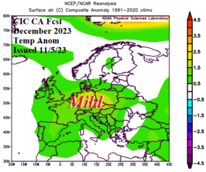
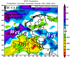
Fig. 16-17: The Climate Impact Company preliminary constructed analog temperature and precipitation anomaly forecast for December 2023 across Europe.
January 2024: The updated forecast indicates potential for a significant upper trough across Europe during January. Consequently, the forecast is adjusted colder for Northern Europe and Western Russia and normally cold for the southern half of Europe. NCEP CFS V2 and ECMWF are not as strong as the constructed analog with the upper trough although this feature is included by each model. The bottom line is mid-winter is trending colder for Europe. The upper trough spawns a snowy pattern across Eastern Europe, Black Sea region, and Western Russia to help sustain the emerging cold.
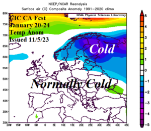
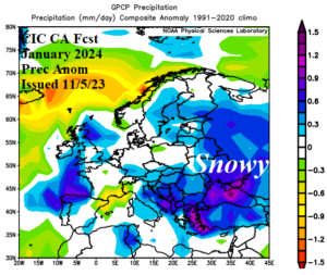
Fig. 18-19: The Climate Impact Company preliminary constructed analog temperature and precipitation anomaly forecast for January 2024 across Europe.
February 2024: The upper trough shifts offshore and is compensated for by an upper ridge over the Black Sea region. The sensible weather pattern features a dramatic regime change from mid-winter with widespread anomalous warmth especially across Western Russia. Forecast confidence is below average due to expected near to above normal snow cover. The storm track leaves a stretch of consistent rainfall across West to North-central Europe and a rain/snow mix in Western Russia. The outlook is consistent with the previous forecast.
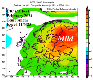
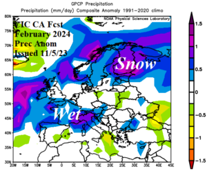
Fig. 20-21: The Climate Impact Company preliminary constructed analog temperature and precipitation anomaly forecast for February 2024 across Europe.
March 2024: The outlook features and amplified ridge yielding a mild early meteorological spring climate pattern for most of Europe and Western Russia. Southern Europe is drier than normal to initiate spring. Wet conditions are likely for the U.K. to Northern Europe.
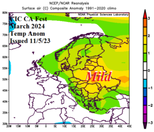
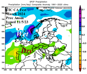
Fig. 22-23: The Climate Impact Company preliminary constructed analog temperature and precipitation anomaly forecast for March 2024 across Europe.