Last Week Great Plains Drought Conditions Worsened; Northern U.S. Snow Cover Continues
04/18/2023, 8:45 am EDTWhere are Northern Hemisphere Drought Concern Areas for Crops?
04/21/2023, 8:14 am EDT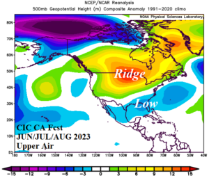
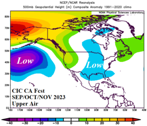
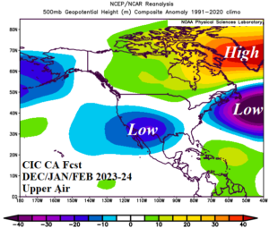
Fig. 1-3: The Climate Impact Company upper air forecast for meteorological summer and autumn 2023 plus winter 2023-24.
Discussion: The North America season 1-3 ahead climate forecast is valid for meteorological summer and autumn 2023 and adding winter 2023-24. Highlights include increasing risk of an upper-level ridge over central North America during summer 2023 as the Central U.S. forecast trends hotter/drier. Most of the U.S. is warmer than normal during summer. The central/southwest Great Plains to Texas drought may expand northeastward during summer before a wet autumn suppresses the dryness. The Texas drought erodes. Next winter looks cold in the Central U.S. and stormy for the East States. Winter 2023-24 could be interesting as an El Nino Southwest U.S. trough develops and combines with a blocking high pressure area over Greenland causing more widespread cold and storminess.
The prevailing upper air forecast: The Climate Impact Company constructed analog (CIC-CA) forecast projects an upper-level high-pressure ridge centered over central North America for summer 2023 (Fig. 1). As a result, the North-central U.S. trend is drier and warmer. The primary influence of the ridge is to trend the U.S. hotter for meteorological summer. Unusual for the 10-year climatology is presence of an upper trough north of Hawaii as projected for autumn 2023 (Fig. 2). The upper ridge associated with the northeast Pacific marine heat wave shifts north and over Alaska. Downstream from the upper ridge extending along the North America West Coast is an upper trough in the East-central U.S. which produces shear to prevent hurricanes from roaming the northern half of the Gulf of Mexico. The upper air pattern projected for winter 2023-24 features the classic El Nino low latitude trough across the Southwest U.S. coupled with blocking high pressure over Greenland (Fig. 3) implying a potentially stormy winter ahead with copious snow.