Bitter Cold Northwest Eurasia and Into Europe; Doubting Major Warm-up to Follow
11/28/2023, 3:57 pm ESTWetter Pattern Change Heading for Central Brazil!
12/05/2023, 5:43 am ESTDiscussion: Based on the Climate Impact Company constructed analog forecasts for winter 2023-24 a look at the prevailing upper air pattern for December, January, and February is provided with annotations as to where (based on the upper pattern) significant snow is likely to occur.
In December, eventually an El Nino storm track into the Southern U.S. yields significant snow risk from the Sierra Nevada eastward to the Southern Rockies (Fig. 1). Included is the Interior Southwest and Great Basin plus western portions of Texas and the southwest Great Plains. In January, the storm track is strongest off the East Coast (Fig. 2). Consequently, significant snow risk is assigned to the Appalachian States and westward to the Mid-south region. In February, the El Nino-induced Southern U.S. storm track peaks in strength and the attendant upper trough yields significant snow risk from the Great Basin to the southern Great Plains to the Appalachian States including the Mid-Atlantic Coast (Fig. 3).
El Nino snowstorms are generally not followed by cold outbreaks. Consequently, snow can erode. Note that the upper air pattern across Canada features mild air supporting high pressure. Arctic air may be difficult to generate during winter 2023-24. The best chance of a “polar vortex” pattern is in February when any arctic air feeding the energetic El Nino Southern U.S. storm track would produce widespread significant cold and snow risk.
The December outlook continues to look mild. The U.S. gas population weight HDD forecast is mild and trending warmer the past couple days for the first half of December (Fig. 4).
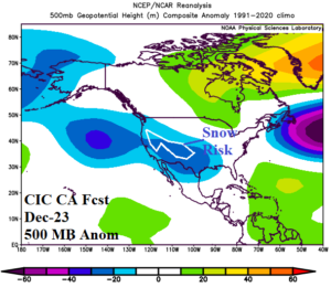
Fig. 1: Climate Impact Company constructed analog forecast for the 500 MB anomaly pattern across North America in December 2023 and where the most likely region for significant snow is located.
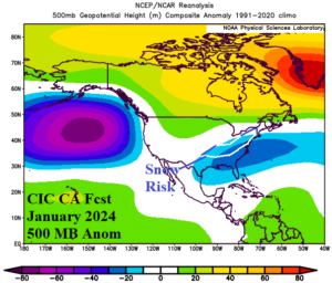
Fig. 2: Climate Impact Company constructed analog forecast for the 500 MB anomaly pattern across North America in January 2024 and where the most likely region for significant snow is located.
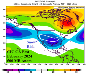
Fig. 3: Climate Impact Company constructed analog forecast for the 500 MB anomaly pattern across North America in February 2024 and where the most likely region for significant snow is located.
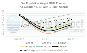
Fig. 4: U.S. population weight HDD forecast based on all models, their consensus, and comparing with 48 hours ago and the 30-year/10-year normal.