El Nino, Marine Heat Waves, and July 2023 Northern Hemisphere Climate Risks
04/30/2023, 11:21 am EDT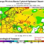
A Look at Summer U.S. and EU/RU New Optimum Climate Normal
05/21/2023, 8:57 am EDTDiscussion: A semi-permanent upper-level high-pressure ridge formed in the Northeast Pacific Ocean and extended to Western North America centered on the 2013-16 period. The upper ridge was well-correlated to the “warm blob” of surface and deep layer ocean water in the Northeast Pacific at that time. The “warm blob” was an example of a marine heat wave (MHW) and the attendant upper air pattern became known as the “ridiculously resilient ridge” (RRR) infamous for accelerating the long-term California drought.
The marine heat wave has persisted since that time. NOAA follows MHW events and has identified the latest version as NEP22A which is now north of Hawaii.
MHW’s are not new, but beginning with the 2013-2016 Northeast Pacific event, they are developing in (many) regions of the global oceans with unusual intensity and developing attendant upper air patterns that regenerate RRR regimes.
The same can be said about cool pools of water which are considerably less than MHW presence. In the northern hemisphere, the most famous cool pool is the North Atlantic warm hole (NAWH) also forming in 2013 and semi-permanent during the past 10 years. The NAWH gets its name due to a persistent stratified cool pool of water at the surface and at depth in the Labrador Sea to south of Greenland caused by accelerated ice melt feeding cold fresh water into this ocean area. The cool pool blocks northeast progress of the Gulf Stream and warming waters from below associated with the Atlantic meridional ocean conveyor (AMOC). The North Atlantic has been warmer than normal for 2-3 decades. The cool pool is the “warm hole” in that otherwise basin-wide warming.
The pattern described has a major influence on the northern hemisphere climate pattern equal to ENSO. We can look at the current SSTA/upper air pattern to identify the relationship. Note MHW NEP22A to the north and northwest of Hawaii and a new MHW off the Northwest Africa Coast (Fig. 1). The NAWH pattern is present south of Greenland. Another regional cool SSTA associated with the cool phase of the Pacific decadal oscillation (-PDO) is off the U.S. West Coast.
The 90-day 500 MB anomalies identify a direct relationship with RRR ridge and trough patterns associated with the MHW and cool pool regimes (Fig. 2). Of course, RRR regimes produce weather extremes. The -PDO cool pool off the West Coast is responsible for record snowfall in the Western U.S. during the past winter. The new MHW off the Northwest Coast of Africa is responsible for drought and early summer heat from Northwest Africa to Spain.
The upper air patterns may dissipate briefly but always seem to return based on the 2014-2022 upper air climatology. Sometimes, the pattern can retrograde (shift west) as projected over the next 15 days (Fig. 3). Note that the -PDO off the U.S. West Coast is shifting westward allowing a recent RRR pattern in Western Canada to expand into the U.S. in the 15-day outlook. The Southwest Europe/Northwest Africa ridge shifts westward and compensated for by a strong trough into the previously hot/dry area. A slight shift in the RRR pattern can produce the opposite weather. The upper ridge associated with MHW NEP22A shifts west to the Dateline.
The catalyst to the retrograding upper air pattern is (likely) related to an expected eastward shift of a vigorous Madden Julian oscillation (MJO). Signs of that eastern shift are apparent as the southern oscillation index (SOI) has dipped to negative phase the past 2 days. The eastern shift of the MJO is likely to create conditions in the equatorial East Pacific Ocean that allow significant subsurface warming to reach the surface and initiate El Nino in June.
ENSO is a leading influence on the global climate. However, the evolving presence of MHW’s during the past 10 years has created an equally important influence on regional climate that creates a compensating and opposite regime to form upstream and downstream. These regional ocean/upper air relationships are increasing the risk of extreme weather and/or climate regimes and are a sensible (real-time) example of climate change.
Climate Impact Company will do a presentation on marine heat waves at the GRAINCOM conference in Geneva, Switzerland next week. Going forward, MHW’s (and cool pools) are a significant influence on your climate forecasts.


Fig. 1-3: Weekly global SSTA analysis identifying persistent regional warm and cool pools, their correlation to the northern hemisphere upper air pattern the past 90 days, and signs of that same upper air pattern retrogressing in the ECM ENS 15-day outlook.