Today’s El Nino East Coast Storm
12/11/2023, 3:09 pm ESTPanama Canal Receives Some Short-term Rainfall but not Nearly Enough to Reverse Shipping Woes
12/13/2023, 1:01 pm EST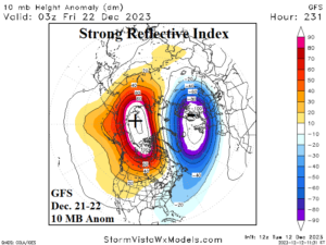
Fig. 1: The GFS forecast of 10 MB height anomalies for the northern hemisphere for later next week.
Discussion: A new approach to forecasting cold weather/cold air outbreaks across North America is utilization of reflection index (RI) based on research recently published by G. Messori, M. Kretschmer, S. Lee, and V. Wendt in Weather and Climate Dynamics and uniquely available on the CWG/Storm Vista Weather Models website. Strong opposing cross-polar 10 MB height anomalies as forecast by GFS in 10 days (Fig. 1) are characteristic of strong +RI events (Fig. 2). The opposing centers are northwest of Alaska and Northern Scandinavia (ideally, Siberia and Canada are preferred). Based on the research, what can follow in 2-3 weeks is a shift in the troposphere of a mild 500 MB ridge pattern over North America (as forecast for the next 1-2 weeks) to shift northwestward forming a ridge bridge pattern over Alaska. Entering the middle third of January each “weeklies” model has a 500 MB ridge shifting across Alaska (Fig. 3-5). Downstream the “ridge bridge” there is a tendency for a cold trough to develop also indicated by each of the “weeklies” models in the East U.S. Implied is a major pattern change from the last half of December as the upper trough chills the eastern and southern U.S. and storminess is likely to feature cold air enhancing snow. RI-induced polar vortex episodes are more common for later January and February therefore this event is too early for arctic air inclusion but certainly a major pattern change from the likely second warmest December of this century in North America.
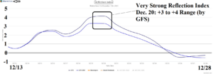
Fig. 2: The 15-day reflective index forecast indicates strong positive values next week.
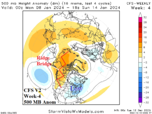
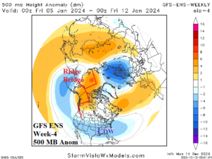
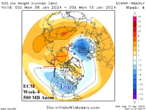
Fig. 3-5: The week-4 ahead 500 MB anomaly forecast valid for the middle third of January approaches indicates a “ridge bridge” pattern near Alaska and a downstream upper trough in the East U.S.