The U.S. Winter 2023-24 HDD Scorecard
11/28/2023, 3:59 pm ESTThe Upper Ocean Heat Increasing East of Dateline
12/04/2023, 11:48 am ESTExecutive summary: Meteorologists and market analysts are gearing up for sudden stratospheric warming (SSW) events which traditionally cause displacement of the polar vortex and arctic air outbreaks into the middle latitudes of North America and Eurasia. However, research has revealed that a different type of stratospheric interaction with the troposphere is causing the most recent arctic outbreaks across North America. The interaction is known as stratospheric downward wave reflection events and involves fast westerlies in the stratosphere reflecting downward into the troposphere causing a strong polar vortex. The most recent research on SDWRE is discussed here and added (as of today) by the SVWM platform is a 16-day SDWRE index forecast (utilizing the GFS model).
Discussion: Traditionally, the strongest cold air events during wintertime across North America and Eurasia are caused by sudden stratospheric warming (SSW) episodes. Energetic Rossby Waves in the tropics turn poleward and upward reaching the polar stratosphere causing the stratosphere to warm and slow down stratospheric wind which sometimes reverses from west to east. The warming stratosphere is reflected downward into the weather atmosphere (troposphere) causing sharp increases in surface pressure and arctic air generation which can easily flow southward to chill North America (and the U.S.) or Europe eastward to China. Recent research reveals this type of cold air generation is less common. However, a different sort of condition in the stratosphere becoming increasingly common during the past 10 years is generating just as intense cold air outbreaks. Recent examples in the U.S. include the winter cold outbreaks of 2013-14, 2017-18, 2018-19, and 2020-21. The new stratospheric-induced cold outbreaks are referred to as “stratospheric downward wave reflection events (SDWRE)”.
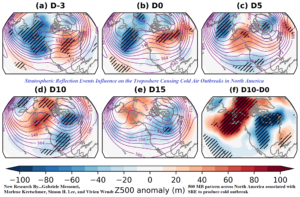
Fig. 1: Evolution of the 500 MB anomaly pattern across North America during SDWRE from onset of event, to 3 days later when troposphere begins to change, and the actual cold pattern arriving 10 days later. The D10 minus D0 chart represents the 500 MB change from beginning to arrival of a polar vortex pattern.
The preliminary understanding of “stratospheric downward wave reflection events” is an increase in stratospheric westerlies around the high-level polar vortex that propagate downward into the troposphere eventually causing an energized polar vortex creating frigid air masses in the middle latitudes. The study “Stratospheric downward wave reflection events modulate North America weather regimes and cold spells” by Gabriele Messori, Marlene Kretschmer, Simon H. Lee, and Vivien Wendt is focused on North America events.
The study reveals that, on average, the 500 MB pattern across North America reflects presence at the onset of the stratospheric downward wave reflection event (SDWRE) of a strong upper trough in the Northeast Pacific extending into Alaska. In about 3 days, the SWRE event begins to cause changes on the troposphere. At the onset of this pattern, the Canadian and U.S. surface temperatures are quite warm. The upper ridge pattern causing the warmth begins to shift westward reaching the Canadian West Coast in 9 days. At that time, a downstream polar vortex begins to form over Northeast Canada. As the event continues to unfold the polar vortex shifts south and amplifies (on average, in 13 days) to cause a cold outbreak in the U.S. The pattern begins to weaken after 7 days. This type of cold air outbreak in North America is becoming more common than traditional SSW episodes.
In conclusion, noting the 500 MB pattern described is helpful to identify potential cold air events ahead. The Storm Vista Weather Models platform, which supplies data for all Climate Impact Company weather forecasts, initiates the SDWRE 15-day forecast today. Positive values indicate a SWRE event may be generating. The current 15-day forecast indicates negative values (Fig. 2).
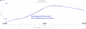
Fig. 2: Storm Vista Weather Models platform initiates the SDWRE index today.