Models Starting to Show La Nina 2024 Developing
12/18/2023, 7:33 pm ESTStratospheric Warming Emerges In Early January!
12/22/2023, 1:05 pm EST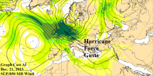
Fig. 1: Graph Cast AI 850 MB wind speed forecast for tomorrow in Europe.
Discussion: Hurricane force wind gusts are projected across U.K. to Germany tomorrow (Fig. 1) due to a potent storm (960 MB) across southwest Scandinavia. By contrast, the high wind (60-80 mph) event in the Northeast U.S. earlier this week, was associated with a 980 MB low pressure system. The high wind continues as the storm moves northeastward late this week. A second high wind event is projected for Dec. 28 as a 970 MB low pressure system moving just north of U.K. passes (Fig. 2). The second event can also produce a hurricane force wind focused on U.K. The storm track producing the high wind events is persistent into early January and causes excessive rainfall targeting U.K. to Germany (Fig. 3). Supporting the high wind/heavy rain episode is an extremely intense negative phase of the Scandinavia Index (Fig. 4) which represents an intense upper-level low pressure trough across Northwest Eurasia.
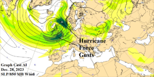
Fig. 2: Graph Cast AI 850 MB wind speed forecast for Dec. 28 in Europe.
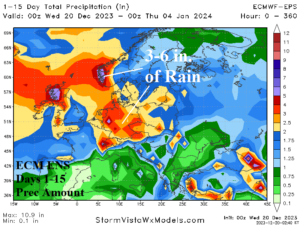
Fig. 3: ECM ENS 15-day precipitation amount forecast across Europe.
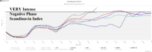
Fig. 4: An extreme negative phase of the Scandinavia Index supports the intense Europe storms.