Equatorial Pacific Subsurface Continues too Steadily Cool
05/06/2024, 1:52 pm EDTU.S. Is 5th Warmest On Record in 2024 So Far
05/08/2024, 12:18 pm EDT
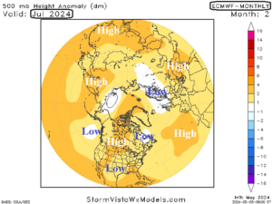
Fig. 1-2: The ECMWF “monthlies” upper air forecast for June and July 2024 across the northern hemisphere.

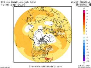
Fig. 3-4: The ECMWF “monthlies” upper air forecast for August and September 2024 across the northern hemisphere.
Discussion: Issued on the 5th of each month is the ECMWF “monthlies” extending to 6 months. The projected upper air forecasts for June through September are indicated (Fig. 1-4).
What we’re looking for are areas of semi-permanent high pressure which best identify areas where anomalous heat and dry climate persist leading to a potential drought. The obvious region exposed to this risk according to ECMWF is Central and Southwest Europe during August and September. The Black Sea region looks hot and dry during mid-summer.
Persistent high-pressure centers across the U.S. are not indicated except for a semi-permanent high pressure over Southeast Canada to New England in August/September. High pressure in this sector has been common during the past 10 years in response to the warming western North Atlantic Ocean. High pressure in this zone causes steering currents of North Atlantic tropical cyclones to extend westward into the Gulf of Mexico or U.S. East Coast and, similar with Harvey in 2017 and Florence in 2018, can cause a slowdown of storms once they reach the coastline which creates unusually heavy rains and flooding.
On their own, ECMWF “monthlies” indicate a Europe drought during summer of 2024 and a hostile North Atlantic tropical cyclone season with considerable risk to the U.S. East Coast and Gulf Coast.