Brazil Drought Concerns; Wet Bias is Stronger with Medium-range Forecasts
12/14/2023, 9:14 am ESTIdentifying The Brazil Drought Trend
12/19/2023, 4:46 am ESTHighlight: Dangerous HIGH WIND along East Coast SUN/MON (and a lot of rain) as El Nino storm passes.
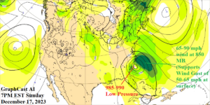
Fig. 1: Graph Cast AI forecast of sea level pressure and 850 MB wind speeds for 7PM EST on Sunday.
Discussion: The upcoming storm for late weekend into early next week on the East Coast is an El Nino storm. Problems: 1.) Develops at a low latitude over very warm water therefore unusually low pressure (980-985 MB off Mid-Atlantic Coast) emerges; 2.) Unusually low pressure running into a high-pressure area southeast of Canada will create hurricane force wind gusts northeast and east of the storm center possibly affecting southern New England and Long Island; 3.) Because the storm was born over warm water, an unusual heavy rain is likely for the Northeast Corridor.
Using Graph Cast AI-generated forecasts, low-pressure plummets to 985-990 MB off the southern North Carolina Coast by Sunday evening (Fig. 1). At 850 MB (5,000 feet), the Graph Cast forecast reveals 67-89 mph wind. About 85% of that wind speed is pulled down to the surface if convection exists which is certainly the case given the birth of this storm over 80F water. Wind gusts to 50-65 mph could touch the outer North Carolina Cape Sunday evening.
By Monday morning, Graph Cast projects a 980-985 MB low-pressure center southeast of Chesapeake Bay (Fig. 2). The strengthening storm system now has 90-110 mph wind speeds at 850 MB east and northeast of the storm center. Once again, about 85% of that wind can be pulled to the surface if heavy convective rains are occurring which is expected and consequently puts Long Island and southern New England at risk of hurricane force gusts Monday morning/midday (and further north near the coast later in the day).

Fig. 2: Graph Cast AI forecast of sea level pressure and 850 MB wind speeds for 7AM EST on Monday.
Graph Cast takes the storm over Long Island midday Monday and northern Maine by early evening. The storm track implicates all eastern New England for wind gusts that are certainly in the 60-mph range and hurricane force near the coast. Widespread power outages are implied.
The 12Z GFS indicates maximum wind gusts at hurricane force on the North Carolina Cape Sunday mid-afternoon. At that time, wind gusts will reach 45 mph as far inland as Richmond. By late Sunday evening, 12Z GFS indicates wind gusts in the 55-60 mph range across Chesapeake Bay to New Jersey with gusts approaching 70 mph on the coast. After midnight Monday morning, wind gusts to 70 mph are forecast by GFS across central and east Long Island to the south coast of New England. Graph Cast suggests the wind gusts could be higher. The 12Z GFS indicates wind gusts to 80 mph across outer Cape Cod Monday morning. Gusts to 60 mph across southeast Massachusetts Monday morning. Finally, hurricane gusts are likely on the Maine Coast for Monday midday.
Several inches of rain (or more) are likely with the passage of this storm. On Sunday, extreme rain and flash flooding is likely in the Carolinas with risk extending to the Mid-Atlantic States Sunday night (Fig. 3). On Monday, excessive rain and flash flooding strikes New England (Fig. 4).
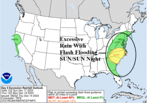
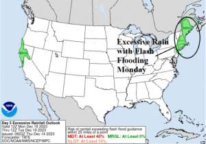
Fig. 3-4: NOAA/WPC flash flood risk areas for Sunday and Monday.