Lighter Than Normal Windspeeds Forecast for U.S. during June/July 2024
05/16/2024, 5:40 am EDTOceanic AND Atmospheric ENSO is Neutral
05/20/2024, 11:41 am EDT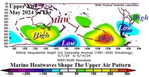
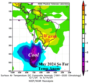
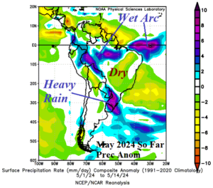
Fig. 1-3: The upper air pattern across the South Pacific so far in May 2024 and the attendant temperature and precipitation anomalies in South America.
Discussion: Strong marine heatwaves (MHW) located west and south of Australia and well east of New Zealand are semi-permanent. Aloft, the atmosphere warms across and downwind these warm water zones causing amplified high-pressure ridging. The upper-level ridge areas cause compensating downstream troughs to form, oner over Argentina during May so far (Fig. 1). In-turn, a nearby subtropical ridge (east of Brazil) forms to compensate for the Argentina trough. This pattern has caused climate extremes in South America during recent weeks including exceptionally cool temperatures in Argentina while Brazil is very warm (Fig. 2) and an in-between historic flooding rainfall for Southeast Brazil (Fig. 3).
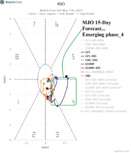
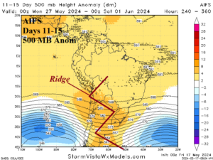
Fig. 4-5: An emerging convection phase of the MJO shifting across Maritime Continent propels a pattern change across South America in 11-15 days.
Changing the pattern described requires a significant shift in intra-seasonal modes of climate variability. The Madden Julian oscillation (MJO) is the first consideration. The 14-day MJO forecast indicates strengthening of the convection phase shifting eastward across the Maritime Continent and into the western tropical Pacific (Fig. 4). Historically, during the shifting to MJO phase_4, the upper air pattern across South America favors an amplified and warming/drying upper ridge forecast by AIFS in the 11-15-day period (Fig. 5).
The 2023-24 MHW off Northwest Africa continues and a new MHW has emerged surrounding Northwest Europe. During May so far, the upper air pattern responds producing amplified upper-level high-pressure ridge areas southwest of Europe and across coastal Northwest Europe (Fig. 6). The ridge areas are east of cool oceanic pools in the North Atlantic causing upper-level trough patterns. To compensate for the Western Europe ridge areas, a deep upper trough formed during recent weeks in West-central Russia. The upper trough caused unseasonably cold air to spread across Russia in May extending southwestward into the Black Sea region (Fig. 7). The precipitation pattern is very dry given the chill and forced heavy rain to form in the Middle East (Fig. 8) enhanced by warm SSTA in the western Indian Ocean.
The influence of the shifting MJO is subtle in the northern hemisphere but enough to cause a slightly progressive pattern in Europe allowing eastward expansion of the Northwest Europe ridge while the Russia trough is weaker and shifting eastward (Fig. 9). Undercutting the Europe ridge pattern is a subtropical low over Southwest Europe responsible for heavy rains (Fig. 10).
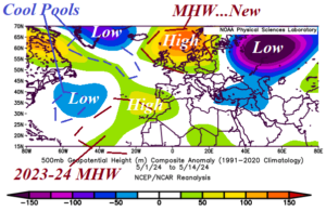
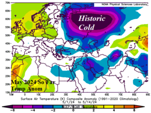
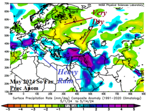
Fig. 6-8: The upper air pattern across the North Atlantic to Russia in May 2024 so far and the attendant temperature and precipitation anomalies for Europe into Russia.
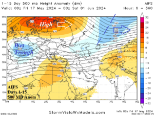
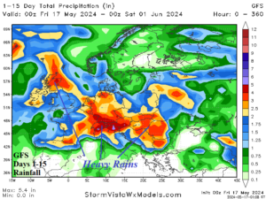
Fig. 9-10: The AIFS 15-day upper air forecast across Europe/Russia and GFS 15-day rainfall outlook.