News
01/28/2024, 1:08 pm EST

Marine Heat Waves and Attendant Upper Air Pattern Influence on Australia Climate

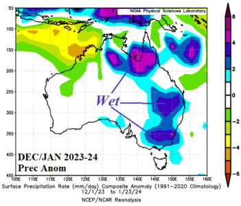
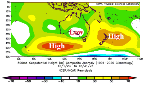
Marine heat waves (MHW) southwest and east of Australia are strengthening during the summer season so far and affecting the prevailing upper air pattern governing the attendant Australian climate. The precipitation climate across Australia so far this summer season is much different from a typical El Nino climate!
01/21/2024, 11:40 am EST

Madden Julian Oscillation Inspires Atmospheric River Storm Track To Develop

What is an atmospheric river? A large and narrow stream of high intensity moisture extending from tropical influences pushed by the jet stream across mid-latitude land masses. The North Pacific atmospheric river is the most famous (and effective). What causes an atmospheric river to form? The best way to create an atmospheric river is the phasing (or connection) between the storm track propelled by the subtropical jet stream and increased heavy convection in the deep tropics enhanced by presence of large areas of strong vertical currents known as the positive (or convection) phase of the Madden Julian oscillation (MJO).
01/09/2024, 4:31 pm EST

Frigid Arctic Air Mass Should Break in About 12 Days

As promised yesterday, a robust convection phase of the Madden Julian oscillation (MJO) shifts into the tropical West Pacific just-after mid-month causing a warming influence to develop on the U.S. climate. Snow cover slows the warm-up in the medium range but note the mega-cluster ensemble “most likely” upper air forecast dissipates the polar vortex and creates high pressure across much of the U.S. in 15 days.
01/03/2024, 12:44 pm EST

Marine Heatwaves And East Australia Heavy Rains

Emergence of a marine heat wave (MHW) east of Australia extending to the east of New Zealand coupled with another elongated MHW across the central and southeast Indian Ocean are well-correlated to high pressure ridge areas. In-between the ridge areas, a low-pressure area has spawned over the central coast of South Australia. The upper trough combined with the warmer SSTA off the East Coast is causing excessive rainfall in Eastern Australia so far during meteorological summer 2023-24.