News
06/26/2022, 8:54 am EDT

Model Verification Indicates Recent Cooler/Wetter U.S. Forecasts Are Overstated

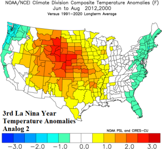
Recent forecasts for the medium range particularly by GFS have turned somewhat cooler after a nationally hot June pattern (so far). The hot June observations (so far) have been driven in-part by a wide area of soil moisture deficits and a drier Eastern U.S. trend. Consequently, the GFS is verifying too cool in the Midwest States (and too warm in the West). Most models have also been biased too wet North-central and East in June.
05/26/2022, 10:04 am EDT

The Amundsen Sea Semi-Permanent Low-Pressure Trough

Beginning in 2020, a large area of low-pressure formed in the Amundsen Sea off the Antarctic Coast well southwest of South America. The upper trough has intensified and persisted through 2022 so far. There is correlation between the presence of this upper trough and winter cold risk in South America.
05/22/2022, 11:07 am EDT

May 2022 North Atlantic TC Seasonal Activity Forecast Update: La Nina Continues – Seasonal Activity Forecast Increases

The Climate Impact Company 2022 North Atlantic seasonal activity forecast has increased slightly since the initial projection one month ago. The number of tropical storms, hurricanes and intense hurricanes each increases by a count of 1 to 20 storms, 10 hurricanes and 5 intense hurricanes. The ACE index increases from 135 to 149. The increase in activity is due to a more confident La Nina climate forecast.
05/12/2022, 2:34 pm EDT

U.S. Summertime in a 3rd Consecutive La Nina Year: Hostile drought!

Historically, ENSO phase entering a 3rd consecutive summer strongly supports widespread hostile drought for the U.S. biased toward the Great Plains historically but likely tilted slightly westward this summer season due to the already strong long-term drought across the western states.