News
05/21/2023, 8:57 am EDT

A Look at Summer U.S. and EU/RU New Optimum Climate Normal

Applied to all climate forecasts is recent historical patterns due to their significant difference from a standard 30-year climatology and driven (mostly) by accelerated ocean surface warming of recent years. Specifically, emergence of a semi-permanent marine heat wave (MHW) in the northeast quadrant of the North Pacific Ocean and similar but opposite (cool) sea surface temperature anomaly regime south of Greenland known as the North Atlantic warm hole (NAWH).
05/10/2023, 8:29 am EDT

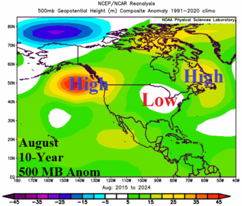
Warm and Cool Regional SSTA and Their Correlation to “Ridiculously Resilient Ridge (and Trough)” Locations

A semi-permanent upper-level high-pressure ridge formed in the Northeast Pacific Ocean and extended to Western North America centered on the 2013-16 period. The upper ridge was well-correlated to the “warm blob” of surface and deep layer ocean water in the Northeast Pacific at that time. The “warm blob” was an example of a marine heat wave (MHW) and the attendant upper air pattern became known as the “ridiculously resilient ridge” (RRR) infamous for accelerating the long-term California drought.
04/30/2023, 11:21 am EDT

El Nino, Marine Heat Waves, and July 2023 Northern Hemisphere Climate Risks

Evolving El Nino coupled with marine heat waves suggest the warmest global ocean temperatures on record are ahead for 2023. As of March, global SSTA were the 3rd warmest in 174 years. Certainly, the super warm global SSTA will influence climate patterns. Of leading interest is where drought areas emerge during the northern hemisphere summer. Right now, concern areas are tropical SSTA-driven drought in Western Indonesia and possibly India while MHW-driven drought returns to Europe and the U.S.