News
11/20/2025, 8:54 am EST
A map of the south america AI-generated content may be incorrect.

Central South America Rains Forecast to Shift Into Brazil

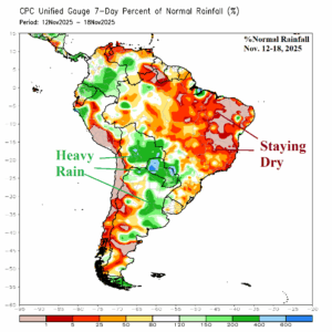
Operational forecasts continue to indicate a wet weather shift to Brazil. The mega-cluster ensemble indicates wet weather risk is highest in Northeast Brazil into the weekend while Argentina turns drier. The drier trend for Argentina is also evident during the medium range while wet focus shifts to East Brazil.
11/17/2025, 4:34 am EST
A graph of different colored lines AI-generated content may be incorrect.

Chicago and Boston Winter 2025-26 Snowfall Forecast

The projected SSTA regime and SSW risk are found in 7 different analog years in the modern climate era (since the mid-to-late 1990’s). Each year has an assigned statistical weight based on the strength of the analog. The consensus of the analog years yields an above normal snowfall each month of meteorological winter 2025-26 in Chicago and Boston (except for February).
11/14/2025, 12:49 pm EST
A graph with a line and arrow AI-generated content may be incorrect.

Is 12Z GFS Arctic Air 11-15-day Period U.S. Forecast Real?

At midday, the 12Z GFS forecasts a whopping -4 value for the East Pacific oscillation (EPO) during the 11-15-day period. Other models are averaging -2 at that timeframe, about half the strength (although still impressive). The strong (-4) index supports arctic air involvement and on day-15, 12Z GFS indicates zero for morning low temperatures from Colorado to South Dakota. Is the forecast overstated?
11/11/2025, 2:43 pm EST
A map of the weather AI-generated content may be incorrect.

Climate Signals Indicate More Interesting Cold Weather for U.S.

An intense negative North Atlantic oscillation (-NAO) weather pattern continues into early next week. Reasonable is the projection by ECM of another intense -NAO inspired upper trough into the Northeast late this weekend. The upper trough triggers more chilly weather although not quite as cold as today plus a major snowstorm over Maine.