News
12/23/2025, 8:23 am EST

La Nina Gains Strength, Strongest Signature of Late 2025 So Far

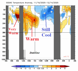
The Nino3 SSTA is the coolest (of this episode) so far at -1.0C. The Nino34 SSTA cools to -0.8C. In the subsurface, the eastern equatorial Pacific Ocean is plenty cool to sustain La Nina. A warm Kelvin Wave shifting east near the Deadline appears to undercut the cool anomaly keeping cooler waters near the surface for trade winds to up-well to the surface.
12/19/2025, 8:36 am EST

Warm Northeast Pacific Enhances “Atmospheric River”

The effectiveness of the “atmospheric river” storm track is enhanced by a surge in warming of the Northeast Pacific. A marine heatwave centered in the Northeast Pacific well northeast of Hawaii has strengthened and expanded to the U.S. West Coast. The warmer ocean surface temperature adds low-level atmosphere moisture entrained by the Pacific storm track and unloaded on the West U.S. with attendant latent heat release warming much of the U.S. for the next 2-3 weeks.
12/16/2025, 4:43 am EST

Historical Precipitation Event Ahead West U.S. – Causes and Implications

The 2025-26 cold season is barely underway and already two dramatic weather regimes are identified: 1.) The just-ending arctic outbreak across the East U.S. and 2.) The evolving excessive precipitation event for the West Coast lasting the remainder of December and into January.
12/14/2025, 10:06 am EST

MJO is Now Quiet, Stratosphere Colder, Therefore, a Milder U.S. Pattern Ahead. But! There are Caveats!

The arctic oscillation (AO) which identifies the location of the polar vortex indicates a change to positive phase the next 1-2 weeks as the recent frigid Canadian polar vortex shifts poleward. The shift toward the North Pole allows milder Pacific maritime influence to warm the U.S. pattern. The extended-range AO forecast suggests the positive phase may continue well into January. However, there are caveats.