News
09/21/2024, 9:03 am EDT

The Likelihood of Abundant Northern Hemisphere Early Season Snow Cover

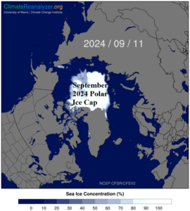
During September 2024 the sea and ice concentration within the polar ice cap is 4th lowest in the 1978-2024 climatology. By comparison, the polar ice cap is considerably smaller than typical of 40+ years ago. The modern-day constricted polar ice cap has contributed to a recent trend of above normal snow cover developing early in the northern hemisphere cold season.
09/13/2024, 11:55 am EDT

Below Normal Tropical Cyclone Activity for Both North Pacific and North Atlantic

The below normal activity in each basin is unusual. The reasons for the below normal activity are under review. In the Northwest Pacific, high-level above normal westerly wind shear across the tropics has limited hurricane development while stronger than normal low-level trade winds have suppressed activity in the deep tropics of the Northeast Pacific and North Atlantic.
09/03/2024, 4:35 am EDT

An Update on North Atlantic Hurricane Forecast Factors

A review of the seasonal hurricane activity predictors is mixed with warm SSTA in the main development region (MDR) supportive of hurricane development while fast trade winds suppressing tropical development have been a significant inhibiting factor.
08/27/2024, 2:34 pm EDT

Indian Ocean Dipole Shifts Negative, Albeit Weak

Currently, the Indian Ocean dipole is in weak positive phase. The western basin is 0.32C warmer than the eastern basin identifying the +IOD regime. The IOD trend of recent weeks is to drift into the weak positive phase. The IOD forecast was a shift into the negative phase for the last third of 2024. Due to the recent rewarming of the western tropical North Atlantic, the -IOD forecast remains, but is generally weaker and not all models project -IOD.