05/12/2026, 1:54 pm EDT

Super El Nino Increasingly Likely. Where are the First (climate) Targets?

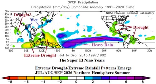
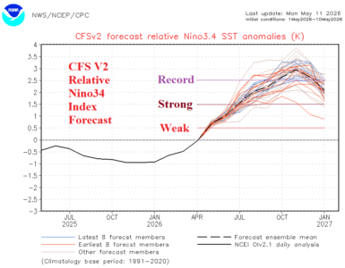
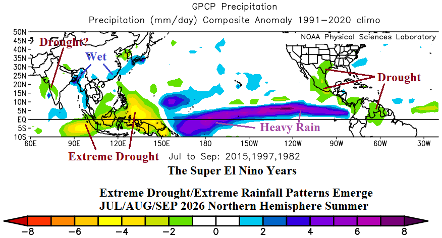
Super El Nino climate is on the way following the equatorial East Pacific warming of the next several months when, beginning in JUL/AUG/SEP, the northern hemisphere tropical/subtropical latitudes are highly impacted by this phenomenon. Most striking is the likely extreme drought for Indonesia. As impressive is the streak of heavy rain across the central and east tropical Pacific Ocean likely to fuel an intense East Pacific tropical cyclone season.
05/12/2026, 9:34 am EDT

Decelerating Solar Intensity

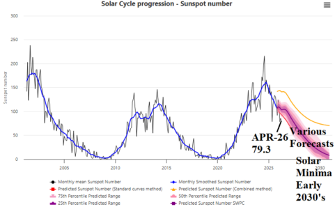
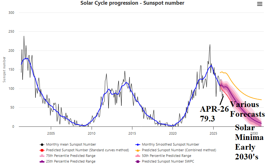
Solar Cycle 25 has passed peak and is now decelerating in intensity which will continue into solar minimum beginning in 2030. Once solar minimum is reached, solar cycle 26 begins. The APR-26 sunspot number was 79.3 and weaker than various forecast model projections.
05/12/2026, 9:24 am EDT

North America SSTA: Western Subtropics and Deep Tropics Significant Warming Ahead

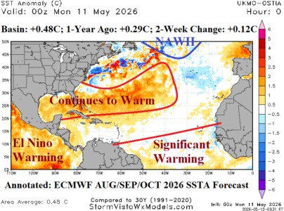
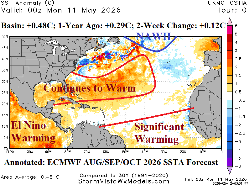
As mid-May approaches, just a few weeks before onset of tropical cyclone season, the North Atlantic basin is moderately warm (+0.48C) which is about 0.2C warmer than one year ago and generally cooler than basin SSTA for this time of year during the past decade. The warm regions are the Gulf of Mexico (basin average +0.88C) and eastward across the Bahamas to southeast of Bermuda. Other areas are cooler than normal, especially off the Mid-Atlantic Coast and southwest of Portugal. The North Atlantic warm hole (NAHW) south of Greenland is developing.
05/11/2026, 12:33 pm EDT

Upper Ocean Heat East of Dateline 2nd Warmest Historically

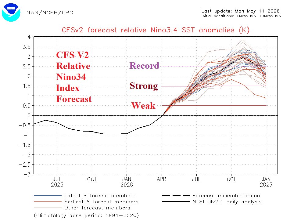
Upper ocean heat index is between +2 and +2.5 for the past 3-4 weeks which is warmest on record for El Nino events EXCEPT for the 1997 episode. Potential energy for El Nino development and intensification is immense.
05/11/2026, 5:03 am EDT

Dynamics To Generate Heavy Rain Texas/Mid-south U.S.; Impressive High Pressure Ridge Days 16-30 Midwest U.S.

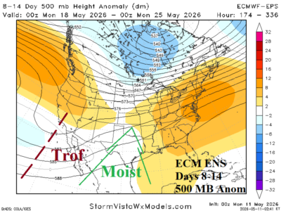
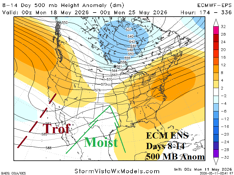
During the 8-14-day period, an upper trough forms off the Baja California Coast. A moist southwest flow aloft develops and enables a wet pattern to develop in Northeast Mexico, Texas, and northeastward toward the Ohio Valley. The prevailing dry pattern of this week is pushed to the northwest Great Plains (and Northwest U.S.). In this set-up, particularly with much warmer than normal SSTA in the Southeast Pacific and Gulf of Mexico, heavy rain/severe weather is likely for Texas to the Mid-south States.
05/08/2026, 1:45 pm EDT

U.S. April 2026 Climate Report

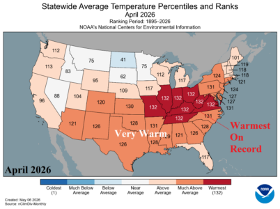
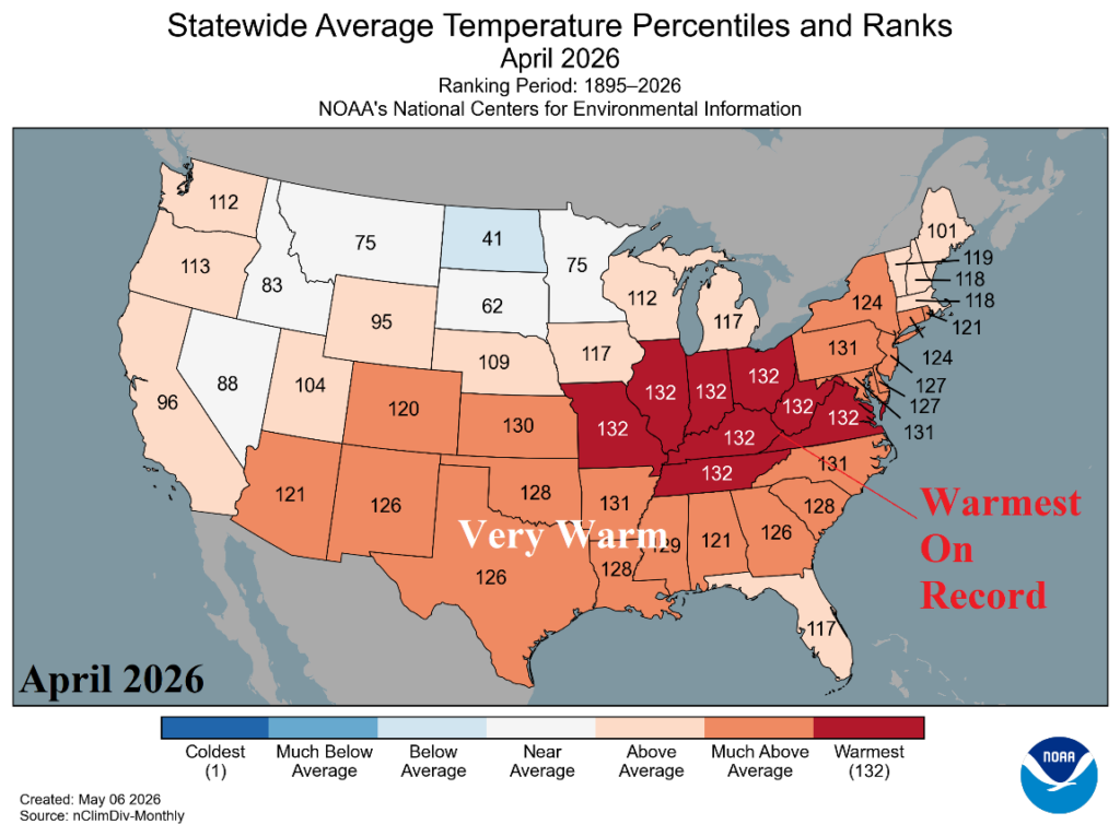
During April 2026, the Ohio and Tennessee Valley to Virginia observed record warmth. Most of the U.S. was MUCH WARMER than normal. The exception was slightly cooler than normal in North Dakota. The April 2026 precipitation pattern featured record amount in Wisconsin and Michigan and VERY WET conditions in Iowa and Missouri. Conversely, The Southeast and Mid-Atlantic States were very dry with several states in the to-5 all-time driest.
05/08/2026, 9:50 am EDT

Global Soil Moisture Anomalies Observations and Trend

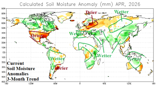
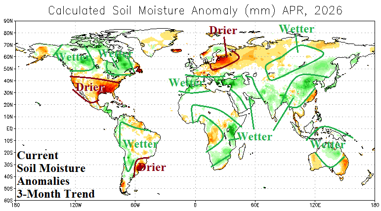
Currently, NOAA/CPC identifies major drought areas across the southeast quadrant of the U.S., developing across the West U.S., and Baltic Region in Europe (Fig. 1). A major drought across Brazil is eroding to summertime rains. Southern Europe to the Iran Conflict region shifted wetter during the first third of 2026. Indonesia to Central Australia shifted wetter although “sneaky” drought developed in East Australia.
05/07/2026, 1:47 pm EDT

Active MJO and/or El Nino Onset to Ignite Wetter U.S. Pattern Not Indicated (Yet)

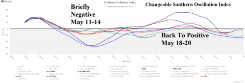
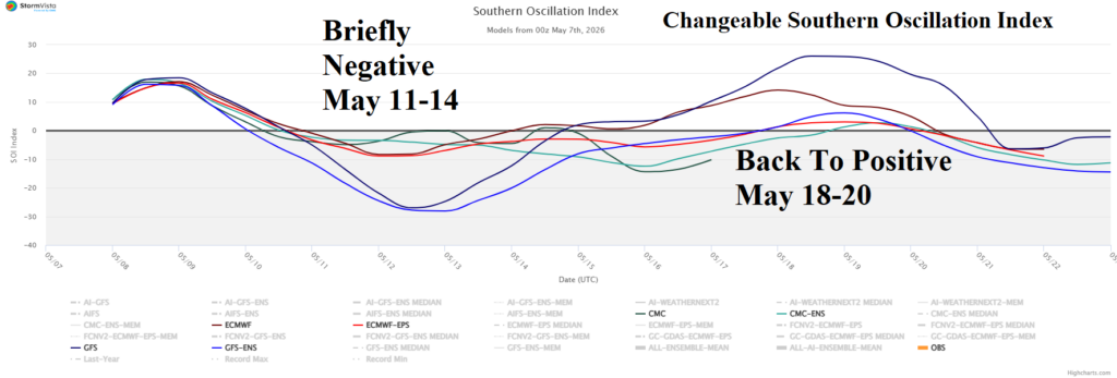
A U.S. pattern change featuring a wetter climate, mostly affecting the Southern States, is forecast by various probabilistic and dynamic models for later this month and early meteorological summer. Required to inspire a wetter pattern is persistent negative southern oscillation (SOI) or the onset and intensification of an El Nino climate.
05/07/2026, 4:33 am EDT

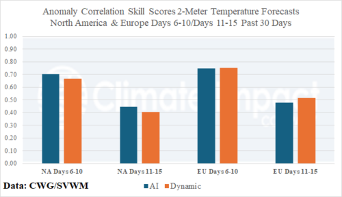
Comparing AI Vs. Dynamic Models 2-Meter Temperature Forecasts North America and Europe

AI models (7) outperform dynamic models (5) in both the 6-10-day and 11-15-day timescales for North America by small margins. In Europe, AI models edge-out dynamic models in both time periods. Climate Impact Company regards 0.75-0.80 as a good skill score for 6-10-day forecasts and 0.55-0.60 as desirable in the 11-15-day period.
05/05/2026, 9:24 am EDT

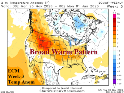
Broadening U.S. Warmth Ahead; Includes Mid-Atlantic

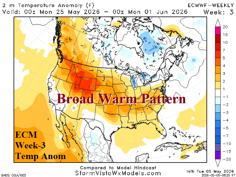
ECMWF broadens high pressure across the U.S. centered on the Great Plains later this month. Support from other models is favoring this solution although some AI models re-cool the East. The sensible weather is widespread anomalous warmth and increasing Great plains hot weather risk. The Southwest U.S. encounters early season clouds/thundershowers.
05/04/2026, 5:28 am EDT

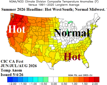
Updated Summer 2026 Outlook: Hot Northwest/West and Gulf States; Wet Midwest; Late Summer Drought Mid-south/Texas

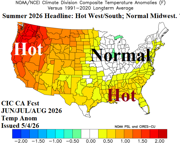
The updated Climate Impact Company summer 2026 outlook indicates a hotter than normal summer season across much of the U.S., especially the Northwest to California and Gulf States while wet climate suppresses anomalous heat risk in the Midwest. Drought expands northwestward in the West and develops Mid-south to Texas later in the summer season.