04/13/2026, 12:01 pm EDT

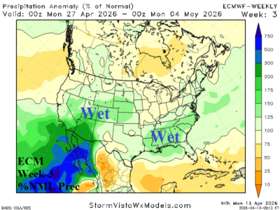
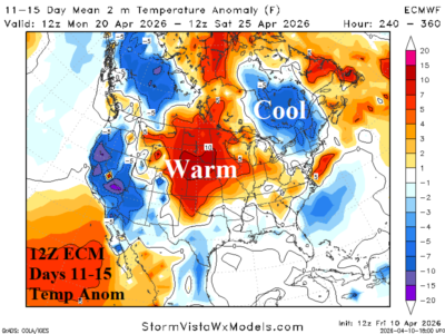
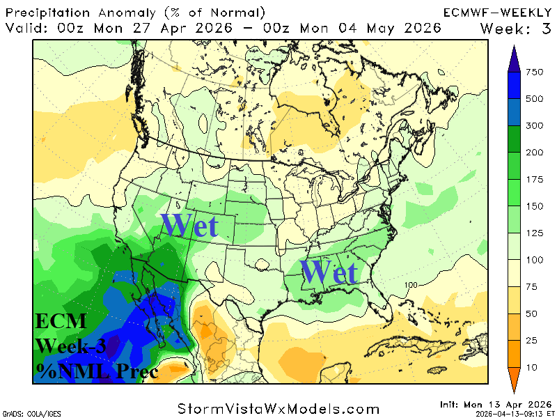
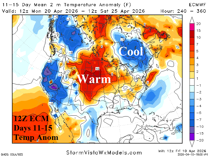
U.S. Week 2-4 Outlook: The National Pattern Cools Off and Turns Wetter

Over the next few weeks, a climate pattern change featuring departing low pressure across Canada departing and being replaced by high pressure while low pressure tendency increases in the subtropical latitudes. The beginning of that pattern appears in the week 2-4 outlook. During the outlook, the U.S. loses the tendency for unusually warm weather and turns wetter while Canada shifts milder.
04/12/2026, 12:42 pm EDT

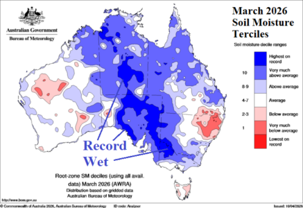
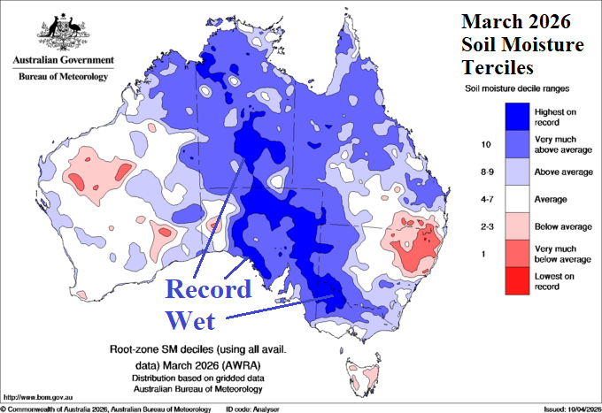
Soaking Wet Soils Central/South Australia as Summer Ends

Summer 2025-26 produced a wet climate and soaking wet soils for central and southern continent where record wet conditions were observed. A drier pattern is indicated for the next few weeks. A climate shift into El Nino should promote a drier climate for next warm season.
04/10/2026, 4:11 pm EDT

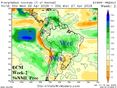
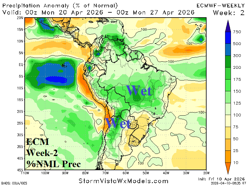
Wet Pattern Ahead in Brazil Abates Early May

The outlook for week-2 ahead features heavy rain across much of Central Brazil to Northwest Argentina while Southeast Brazil is dry and hot. The wet weather moves into Northeast Brazil late month. In early May, Brazil shifts drier while wet weather regenerates in Argentina.
04/08/2026, 3:07 pm EDT

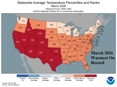
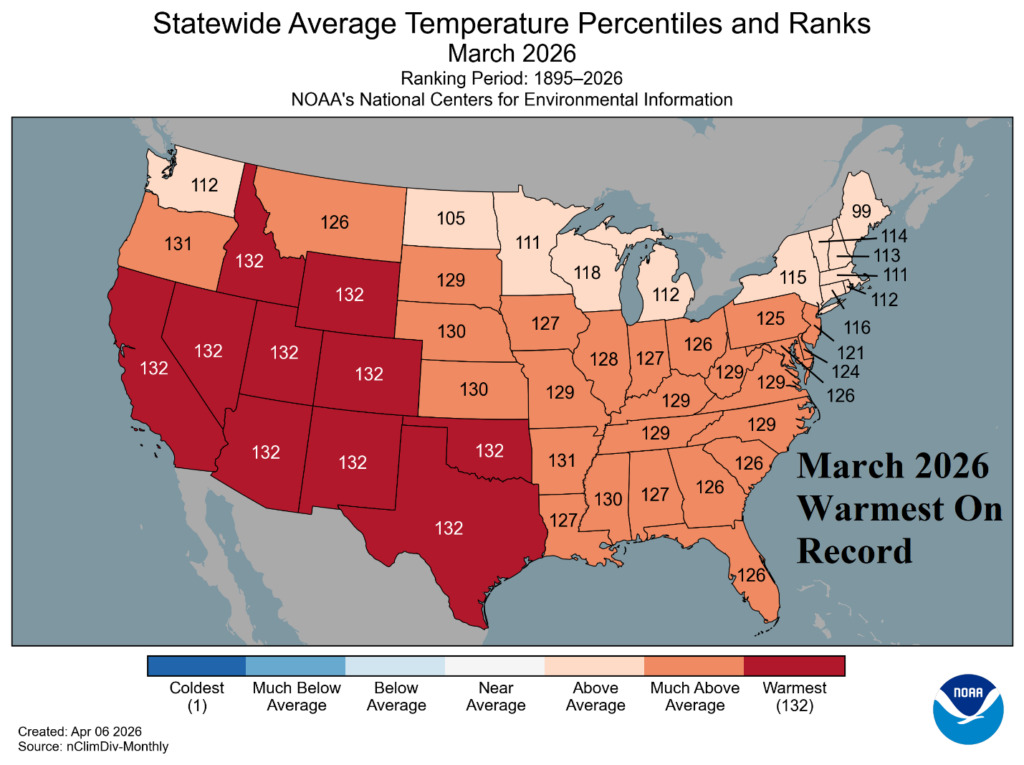
Warmest March on Record in U.S.

Semi-permanent high pressure associated with the record strength and intensifying marine heatwave (MHW) off the California and Baja California Coast maintains the record warmth across much of the West and Southwest U.S. during March. Near record warmth was observed across the Central and East U.S.
04/08/2026, 5:20 am EDT

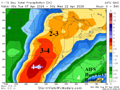
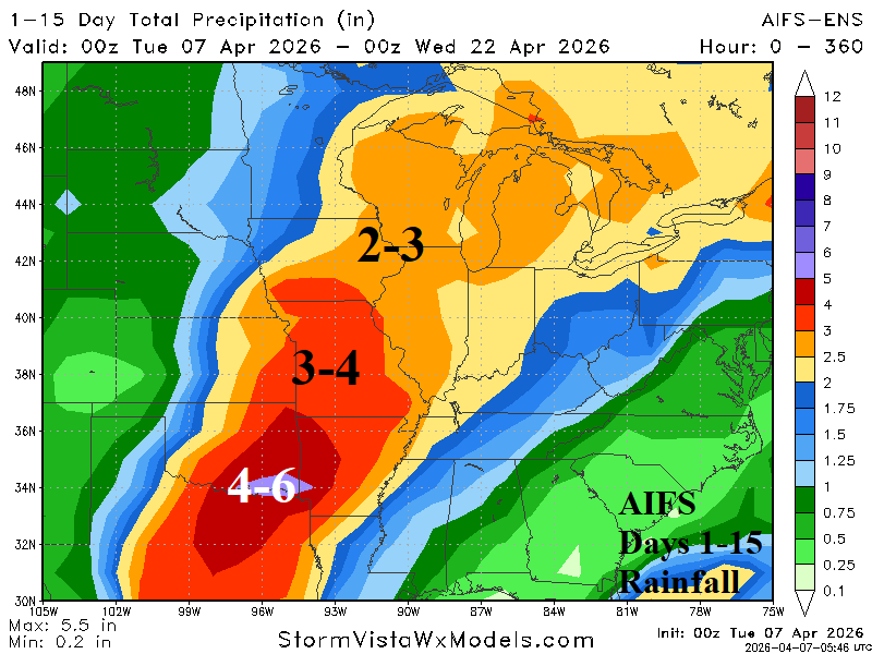
Are Central U.S. Forecasts Too Wet?

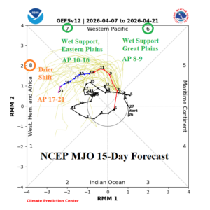
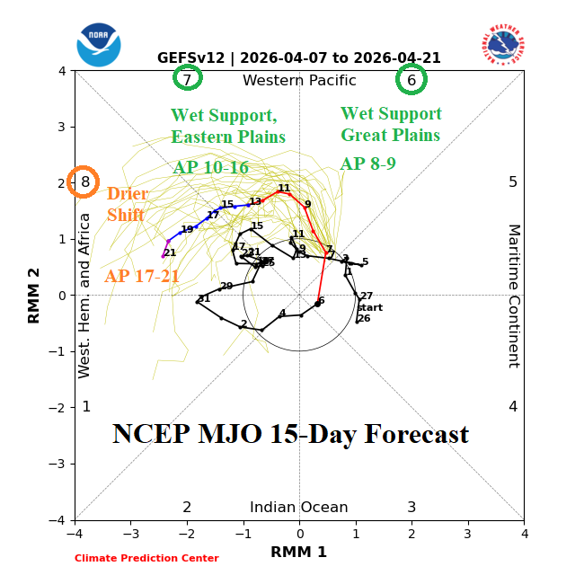
Support for excessive rainfall in the Central U.S. during the next 15 days is below average. To produce excessive rainfall, tropical forcing performed by presence of Madden Julian oscillation (MJO) influence is necessary. The MJO is positioned to influence Central U.S. rainfall the remainder of this week but (wet) influenced is diminished in the medium range.
04/08/2026, 5:17 am EDT

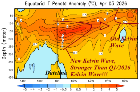
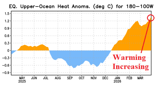
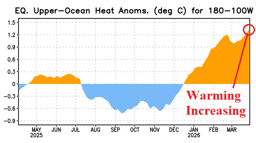
Upper Ocean Heat Surge Supports Record-strength El Nino Risk for 2026!

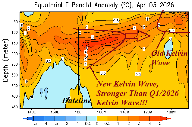
Suddenly, an immense Kelvin Wave has emerged just east of the Dateline in the equatorial Pacific Ocean likely to shift eastward during the next several weeks and accelerate upper ocean heat to fuel El Nino onset. The rate of expected warming is similar with the strongest El Nino’s on record in 2015 and 1997. Analogs and dynamic models are supportive of a potential record strength El Nino in 2026.
04/07/2026, 8:16 am EDT

Is Wet Forecast for the Central U.S. too wet? Western Plains Trend Drier.

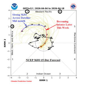
NOAA/SPC indicates associated emergence of severe thunderstorms across Texas and the southern Great Plains later this week. MJO shifts eastward, past the Dateline and toward the Americas (phase_7/phase_8) through the middle third of April. During that time, tropical forcing to enhance Central U.S. rainfall is directed at the southeast Great Plains to the Midwest and then farther eastward (and weakening).
04/07/2026, 8:11 am EDT

Southeast U.S. Becoming a Warm-to-Hot Air Mass Source Region

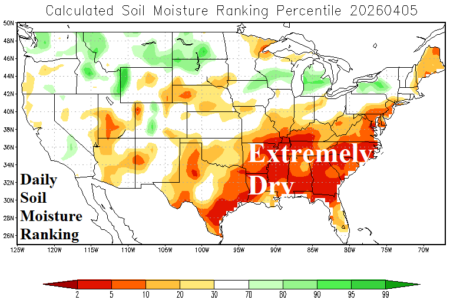
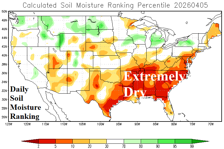
The southeast quadrant of the U.S. daily soil moisture rankings observations reveals historically dry conditions. As the warm season approaches, large regions of dry soil have increasing risk of extreme heat which can worsen drought.
04/06/2026, 1:07 pm EDT

Neutral ENSO; Upper Ocean Heat Increasing

The Nino SSTA regions observed no change last week as neutral ENSO persists. The waters have warmed near the Dateline reaching the El Nino threshold while Nino34 remains neutral. Upper ocean heat in the equatorial East Pacific accelerated earlier this year and lowered slightly in early March. However, upper ocean heat east of the Dateline in the equatorial region has re-intensified and is strongly supportive of an El Nino event ahead.
04/05/2026, 9:21 am EDT

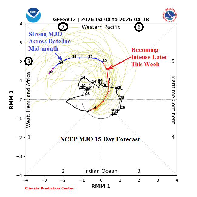
Emerging Madden Julian Oscillation to Dominate Middle Third of April across U.S.

Tropical forcing on the prevailing climate across North America increases during April. The Madden Julian oscillation (MJO) increases strength dramatically as the middle third of April arrives. The MJO shifts toward and across the Dateline during this time. In the extended range, ECMWF maintains the MJO intensity and indicates a progressive character shifting eastward through the tropical longitudes of the Americas to West Africa by early May.
04/02/2026, 9:58 am EDT

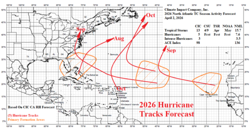
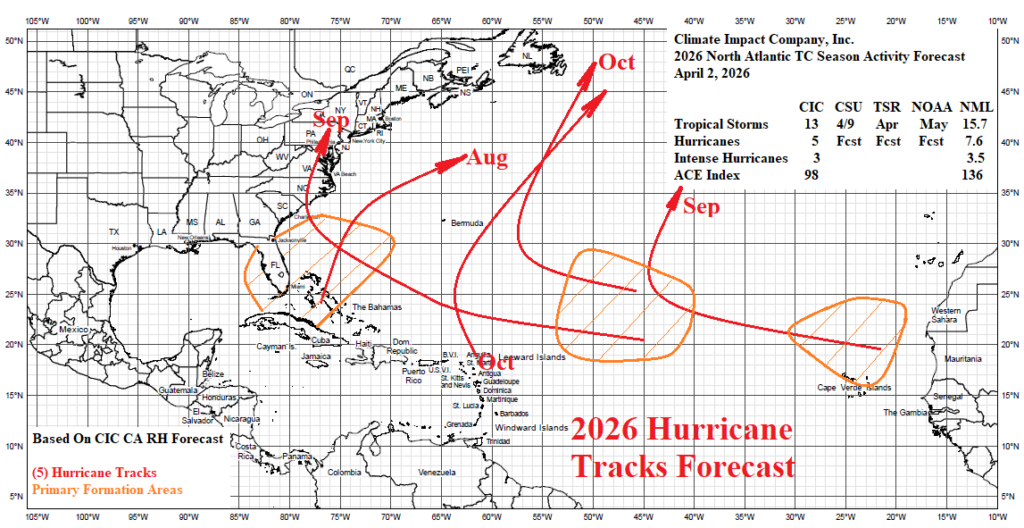
2026 North Atlantic Basin Tropical Cyclone Season Outlook

The initial North Atlantic basin seasonal activity forecast for the North Atlantic basin by Climate Impact Company is issued. The forecast is updated in late May as the onset of tropical cyclone season arrives and again near August 1st when the onset of highest seasonal activity arrives. The forecast projects 13 tropical storms, 5 hurricanes, and 3 intense hurricanes. An El Nino episode develops during the tropical cyclone season inhibiting development and 2026 is the second least busy year during the 2016-2025 active period.