10/21/2025, 4:38 pm EDT
A map of a hurricane AI-generated content may be incorrect.

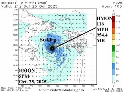
Will Melissa Be an RI Candidate?

Upper shear is inhibiting development. However, once an organized inner core has formed, given the 86F/30C SST which is 1-2C warmer than normal and 3rd warmest upper ocean heat on record for the Caribbean Sea, there is potential for rapid intensification (RI) as early as Thursday (HWRF) or later this week (HMON) to a strong category-2 hurricane or category-3 major hurricane.
10/21/2025, 5:30 am EDT
A map of the south america with hot weather AI-generated content may be incorrect.

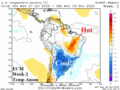
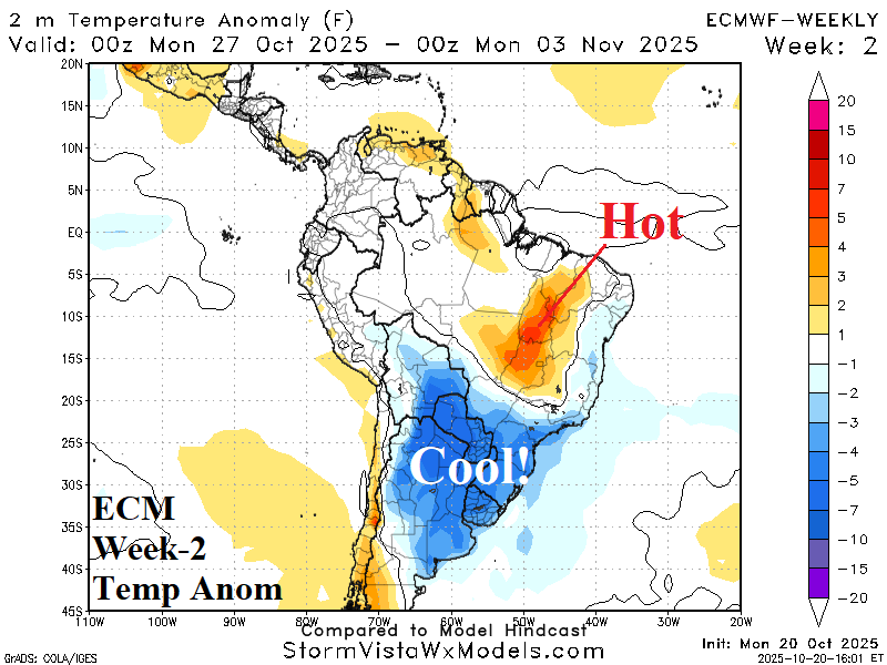
Cool Air Masses South America; Brazil Rains 1st Week of November

One cold front has plowed into Northeast Brazil this week and another stronger front shifts across Argentina late week/early weekend. The second front delivers a widespread cool air mass for next week across Argentina. The supporting upper trough cuts off over central South America in early November to deliver wet weather to the Brazil drought zone.
10/20/2025, 7:30 pm EDT
A map of the united states AI-generated content may be incorrect.

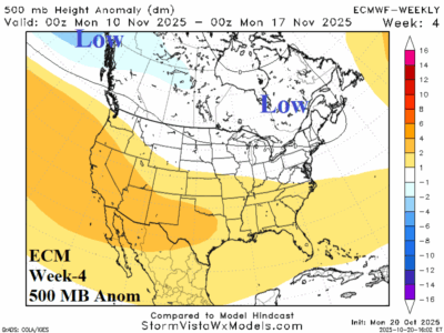
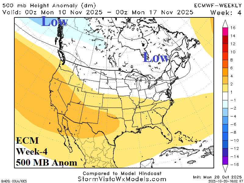
Week-4 Upper Air Forecasts for North America

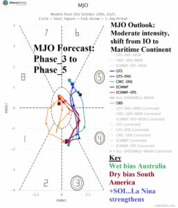
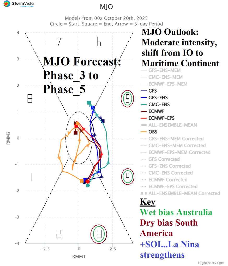
The upper air forecast for week-4 is highly variable ranging from an amplified (warm) Central U.S. high pressure ridge according to CFS V2 to a deep cool upper trough centered on New York based on the 4Cast Net V2 ECM ENS, or somewhat of a compromise by ECMWF. MJO projections for mid-November are in phase_6 (near the Dateline) which favors a warm solution for the U.S. ECM is the chosen model with CFS V2 the caveat forecast while leaning away from the cooler East AI scenarios.
10/20/2025, 7:28 pm EDT
A graph with a line and a line AI-generated content may be incorrect.

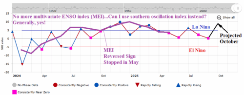
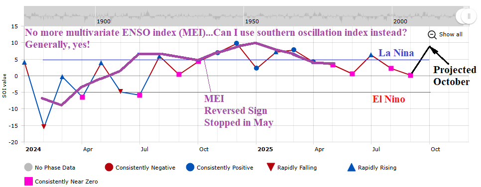
Can I Use Southern Oscillation Index to Approximate Multivariate ENSO Index?

NOAA’s multivariate ENSO index (MEI) changed its data input from the Japanese Meteorological Agency’s JRA-55 reanalysis dataset to JRA-3Q as of January 2024. However, the data has not been attainable since May although NOAA claims the data is available (although hard to decipher with the government shutdown). MEI is a handy climate diagnostic identifying the atmospheric reaction to the SSTA/SLPA pattern across the Pacific tropics/subtropics.
10/16/2025, 9:08 am EDT
A map of the united states AI-generated content may be incorrect.

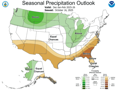
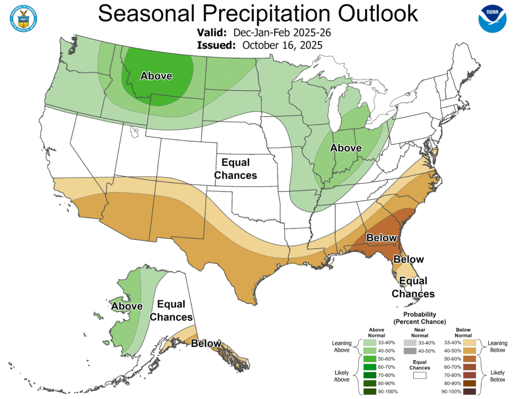
NOAA/CPC Winter 2025-26 Outlook is Edging Colder/Snowier

The NOAA/CPC meteorological winter 2025-26 forecast is cold and snowy across the northern states from Washington to Michigan while the Ohio Valley turns stormy likely favoring snow. The southern tier of the U.S. is dry and warm.
10/16/2025, 8:19 am EDT

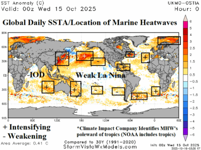
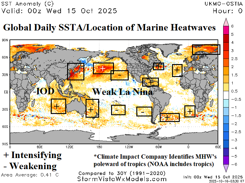
October 2025 Marine Heatwave Outlook

The latest marine heatwave report identifies many large episodes in the northern hemisphere, common during early autumn in the current decadal pattern. Strongest marine heatwaves are off the East Asia Coast, Central Pacific, and off the Northwest Eurasia Coast. The "warm blob" in the Northeast Pacific during late summer has rapidly weakened during the past several weeks. Southern hemisphere marine heatwaves will strengthen as summertime arrives.
10/15/2025, 7:04 am EDT
A map of the world AI-generated content may be incorrect.

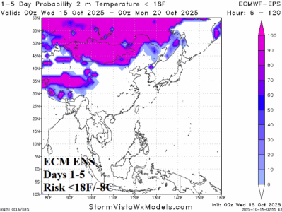
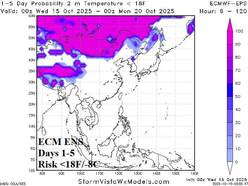
Early Season Hefty Snow Cover, Causes Cold Air Mass, Release Into China Next Week

The early season snow cover across the northern hemisphere is ahead of schedule in Mongolia, far Northeast China, and Southern Russia. Alaska and Canada have below normal snow cover for mid-October although a recent streak of snow was observed across parts of the Canadian Prairies. As usual, early season expansive snow cover encouraged a much colder than normal air mass to evolve across Northeast Eurasia featuring 5-day temperature anomalies of 20-30F below normal.
10/15/2025, 7:01 am EDT
A graph of the weather AI-generated content may be incorrect.

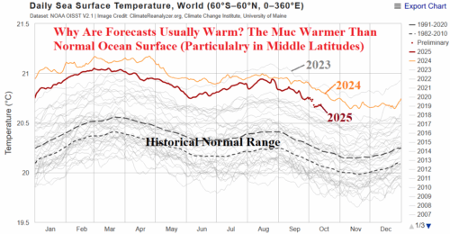
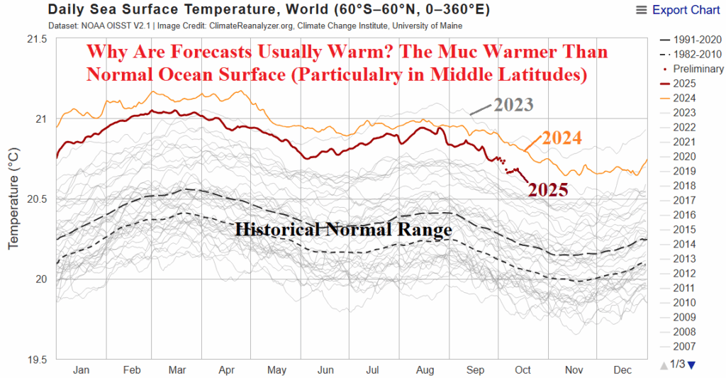
The Warm Oceans, Causal to Warm Medium-range Forecasts

Day-to-day, medium/extended-range forecasts in North America are usually warmer than normal. A leading catalyst to that regime is much warmer than normal global ocean surface, most apparent in the middle latitudes beneath the prevailing upper-level westerlies that drive out climate. Maine heatwaves have increased dramatically in the middle latitudes particularly in recent years.
10/14/2025, 9:21 am EDT
A graph of different colored lines AI-generated content may be incorrect.

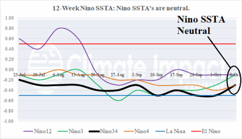
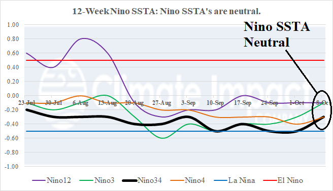
Nino SSTA Neutral Despite Onset of La Nina Announcement by NOAA

Last week, the Nino SSTA regions each warmed slightly and are all in neutral range as mid-October approaches. Despite neutral Nino SSTA, NOAA announced La Nina onset last Thursday. The subsurface equatorial East Pacific is broadly cooler than normal. The trend is slightly cooler from 2 weeks ago.
10/13/2025, 4:47 pm EDT
A map of the earth AI-generated content may be incorrect.

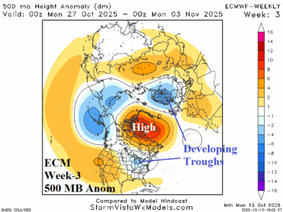
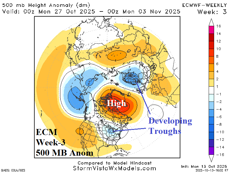
Pattern Change Eastern U.S. Later October

ECM projects the Greenland Block to continue and finally produce cool troughs into the Ohio Valley/Mid-Atlantic States and Northwest Eurasia late this month into early November. Expect a cooler U.S. pattern especially in the East, as November approaches.