News
04/08/2026, 3:07 pm EDT

Warmest March on Record in U.S.

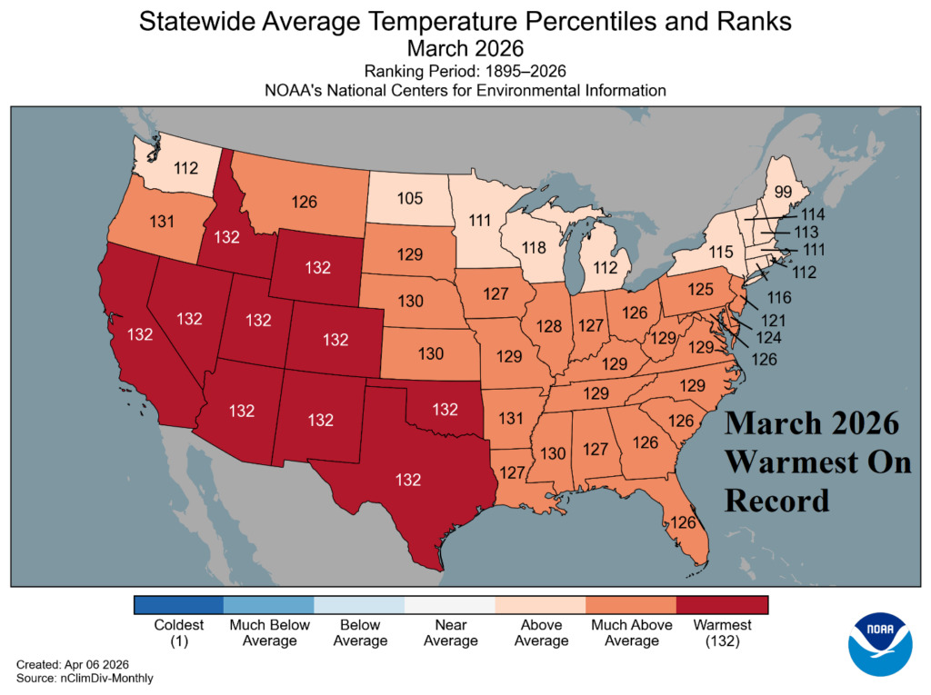
Semi-permanent high pressure associated with the record strength and intensifying marine heatwave (MHW) off the California and Baja California Coast maintains the record warmth across much of the West and Southwest U.S. during March. Near record warmth was observed across the Central and East U.S.
04/08/2026, 5:20 am EDT

Are Central U.S. Forecasts Too Wet?

Support for excessive rainfall in the Central U.S. during the next 15 days is below average. To produce excessive rainfall, tropical forcing performed by presence of Madden Julian oscillation (MJO) influence is necessary. The MJO is positioned to influence Central U.S. rainfall the remainder of this week but (wet) influenced is diminished in the medium range.
04/08/2026, 5:17 am EDT

Upper Ocean Heat Surge Supports Record-strength El Nino Risk for 2026!

Suddenly, an immense Kelvin Wave has emerged just east of the Dateline in the equatorial Pacific Ocean likely to shift eastward during the next several weeks and accelerate upper ocean heat to fuel El Nino onset. The rate of expected warming is similar with the strongest El Nino’s on record in 2015 and 1997. Analogs and dynamic models are supportive of a potential record strength El Nino in 2026.
04/07/2026, 8:16 am EDT

Is Wet Forecast for the Central U.S. too wet? Western Plains Trend Drier.

NOAA/SPC indicates associated emergence of severe thunderstorms across Texas and the southern Great Plains later this week. MJO shifts eastward, past the Dateline and toward the Americas (phase_7/phase_8) through the middle third of April. During that time, tropical forcing to enhance Central U.S. rainfall is directed at the southeast Great Plains to the Midwest and then farther eastward (and weakening).