News
04/14/2026, 9:39 am EDT

Unusual Early Season West Pacific Major Typhoon Sinlaku Indicates Potential for Busiest North Pacific TC Season on Record

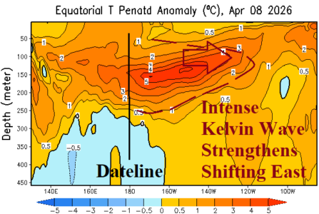
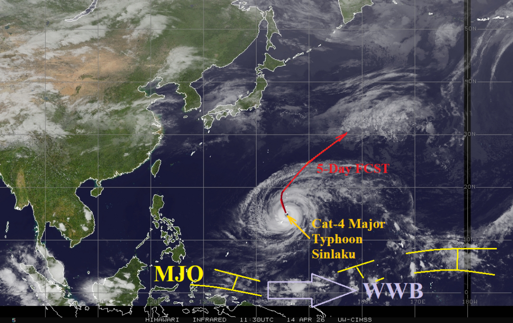
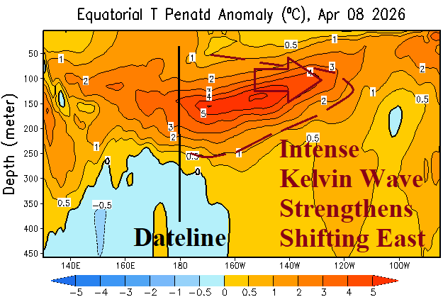
A strong westerly wind burst (WWB) in the Pacific Ocean tropics between 140E and 160E also located across warm sea surface temperature anomalies (SSTA) and robust subsurface upper ocean heat helped spawn an early season unusually strong category-5 major typhoon (Sinlaku). The ingredients helping to ignite this early season intense storm to develop are shifting eastward and will ignite El Nino in May with rapid intensification likely to follow.
04/13/2026, 12:03 pm EDT

Immense Subsurface Kelvin Wave East of Dateline Promises Intense El Nino Ahead in 2026

Neutral ENSO continues during early April as the Nino34 SSTA is unchanged at +0.2C. Last week, some warming was observed off the northwest coast of South America (Nino12). The subsurface upper ocean heat is MUCH warmer than normal and intensifying. The NEW Kelvin Wave features ocean temperatures 6-7C warmer than normal extending to just east of 150W and further eastward shifting is likely.
04/13/2026, 12:01 pm EDT

U.S. Week 2-4 Outlook: The National Pattern Cools Off and Turns Wetter

Over the next few weeks, a climate pattern change featuring departing low pressure across Canada departing and being replaced by high pressure while low pressure tendency increases in the subtropical latitudes. The beginning of that pattern appears in the week 2-4 outlook. During the outlook, the U.S. loses the tendency for unusually warm weather and turns wetter while Canada shifts milder.
04/12/2026, 12:42 pm EDT

Soaking Wet Soils Central/South Australia as Summer Ends

Summer 2025-26 produced a wet climate and soaking wet soils for central and southern continent where record wet conditions were observed. A drier pattern is indicated for the next few weeks. A climate shift into El Nino should promote a drier climate for next warm season.