News
12/08/2025, 4:27 am EST
A map of the united states AI-generated content may be incorrect.

Cold Retreat, Operational/AI Models Warm U.S. Extended-range

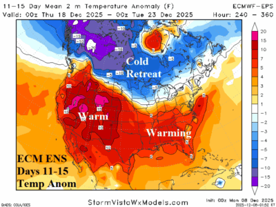
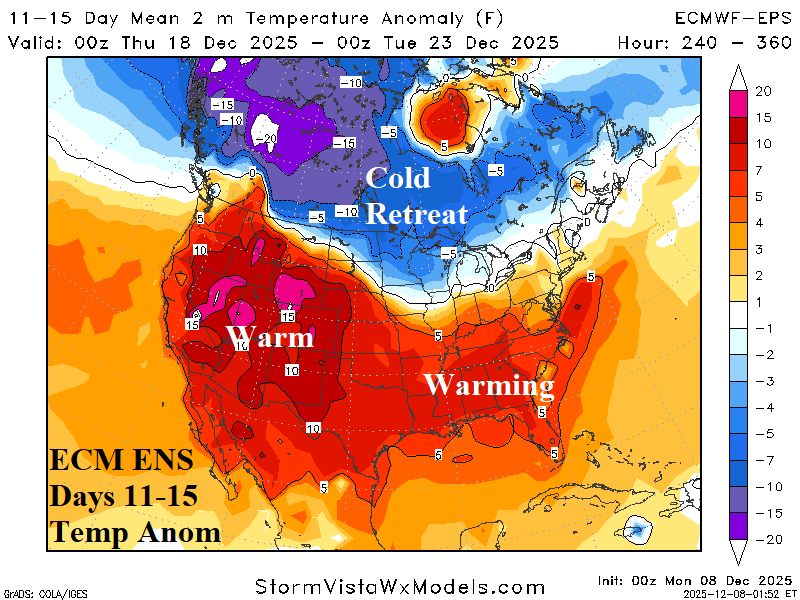
Theme of the Monday morning extended range U.S. temperature anomaly forecast is warmer. The most dramatic warmer change is the consensus of operational models forecast for the week ending Christmas Day and AI projections for early January.
12/07/2025, 2:50 pm EST
A graph showing the weather forecasts AI-generated content may be incorrect.

In U.S. Climate Signals Support Colder West/Warmer East Extended-range

Climate signals forecasts identify provide clues as to where the weather pattern is heading after mid-December. The West Pacific oscillation (WPO) and Pacific North America (PNA) index is negative after mid-December supporting a shift and expansion of the cold pattern over western North America. Negative East Pacific oscillation (-EPO) spikes in one week as another “polar vortex” cold outbreak strikes the U.S. The North Atlantic oscillation (NAO) aggressively shifts to positive phase during the medium range supporting an eastern North America warm-up and validating the -WPO/-PNA colder support in the West. The question is whether -NAO warmth can eat away at the snow cover validating very warm 11-15-day forecasts by ECM.
12/07/2025, 2:46 pm EST
A map of a storm AI-generated content may be incorrect.

Deluge of Rain for Central/East-central South America

In South America, rainfall forecasts have shifted wet risk to Brazil during the past 1-2 weeks. The 7-day percent of normal observed rainfall identifies wetter Brazil weather while rains linger in Argentina. Low pressure areas spawn heavy rain the next 1-2 days Paraguay into Brazil and Northeast Argentina late this week. Additional heavy rain is projected in the 6-10-day and 11-15-day period centered east of Paraguay.
12/05/2025, 6:30 am EST
A graph of snow cover anomalies AI-generated content may be incorrect.

Northern Hemisphere Snow Cover for NOV-25 Near Normal But Lowest Amount Since 2009

The North America and Eurasia snow cover during November were near normal and consequently northern hemisphere snow cover was near normal and the least snowy since November 2009. Note one of the coldest winter seasons on record followed as DEC/JAN/FEB 2009-10 was frigid! Early season snow cover dictating the following winter weather pattern was a reasonably reliable climate diagnostic late last century but less so in this century.