09/15/2025, 11:45 am EDT
A graph with red and blue lines AI-generated content may be incorrect.

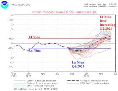
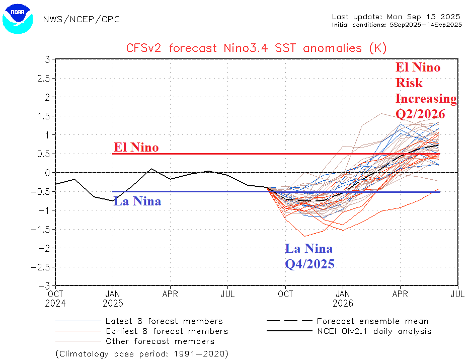
Flip to El Nino in 2026 Increasingly Confident

Emergence of the marine heatwave in the Northeast Pacific potentially increases the risk of El Nino in 2026 as the anomalous warm water spreads to the tropics. The NCEP CFS V2 Nino34 SSTA forecast continues to edge into El Nino territory Q2/2026. The change in ENSO will be applied to new season 1-4 ahead forecasts. The upcoming La Nina is a relatively short duration episode.
09/15/2025, 5:04 am EDT
A graph showing the temperature and the temperature of the year AI-generated content may be incorrect.

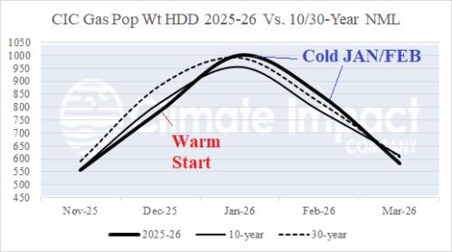
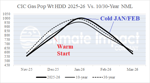
Initial 2025-26 U.S. Heating Season Gas Population Weight HDD Forecast

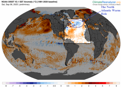
The preliminary U.S. winter 2025-26 gas population weight heating degree day forecast is issued. The outlook indicates near the 30-year normal HDD for November, somewhat warmer than normal December, shifting colder than normal mid-to-late winter, and a mild March. Due to the presence of a strong marine heatwave (MHW) in the Northeast Pacific combined with a stronger than normal North Atlantic warm hole (NAWH) south of Greenland, the risk of an “Alaskan ridge bridge” and compensating downstream polar vortex over Central Canada increases for JAN/FEB 2026 if the sea surface temperature anomaly (SSTA) patterns present now persists through meteorological winter.
09/12/2025, 8:42 am EDT

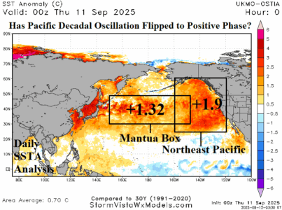
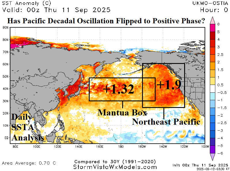
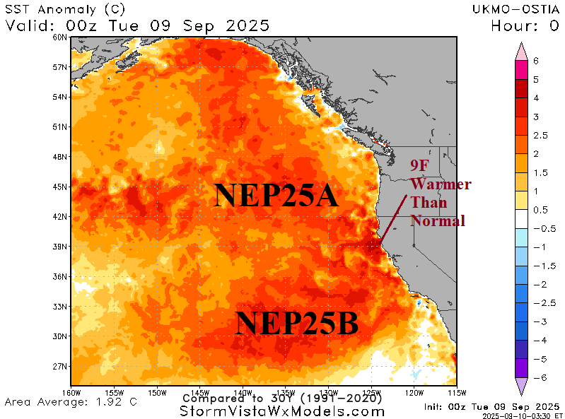
Has the Pacific Decadal Oscillation Flipped to Positive Phase?

Merging between marine heatwave (MHW) NEP25A and NEP25B occurred during late AUG/early SEP as exceptionally warm sea surface temperature anomalies (SSTA) reached the West Coast of North America in the Northeast Pacific. The warming water surface episode is similar with the previously strongest warming event observed during 2013-16, commonly referred to as the “warm blob”.
09/11/2025, 6:07 am EDT
A map of the united states with weather AI-generated content may be incorrect.

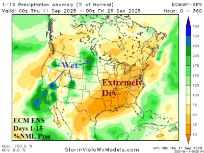
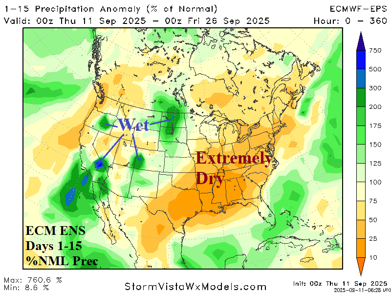
Super Dry Pattern East/South U.S. Continues

The remarkably dry weather pattern across the South and East U.S. shifts stronger in the overnight ECM ENS 15-day forecast. Patchy wet monsoon moisture is confined to the western half of the U.S. In the 16-30-day period, the best fit forecast is the AI Graph Cast ECM ENS which reveals increasing wet risk across the U.S. although the East remains mostly drier than normal.
09/11/2025, 4:56 am EDT
A map of the north pole AI-generated content may be incorrect.

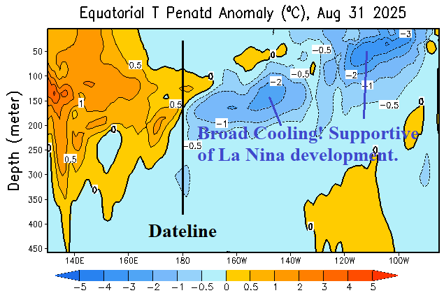
Short-lived La Nina Ahead; Vigorous Marine Heatwave Could Initiate El Nino in 2026

A short-lived La Nina is ahead and supported by vast cooling of the subsurface equatorial East Pacific during recent weeks. However, if the warming Northeast Pacific persists in early 2026, the La Nina episode ends, possibly abruptly and the warm waters of the Northeast Pacific spread south possibly causing an El Nino onset middle third of 2026 which could become intense later next year.
09/09/2025, 12:22 pm EDT
A map of the united states AI-generated content may be incorrect.

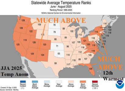
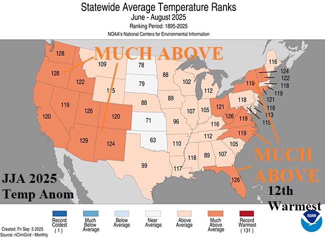
U.S. Meteorological Summer and August (2025) State Climate Rankings

August 2025 brought a cool surprise to the East U.S. including the 7th coolest in the 131-year record for South Carolina. Meanwhile the West, Southwest, and far South U.S. were MUCH ABOVE normal during August 2025. The dryness in the Missouri Valley to New England was profound featuring record dry for Kentucky, Ohio, and Vermont. Georgia was excessive wet during August. The Arizona heat observed in August was the second hottest on record.
09/09/2025, 4:57 am EDT
A map of the world with numbers and a map of the world AI-generated content may be incorrect.

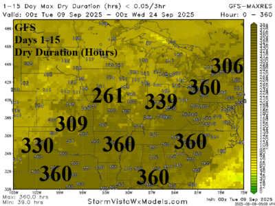
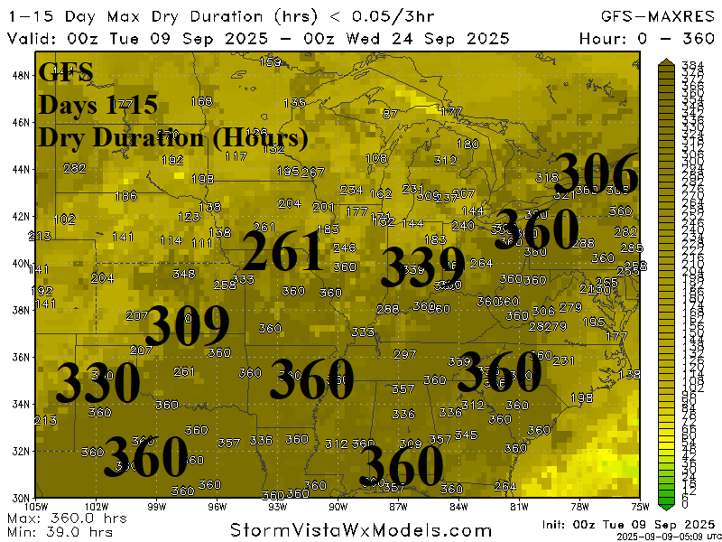
Long Duration Dryness Ohio Valley to Southeast U.S. Closes Calendar Summer

Late calendar summer dryness is excessive across the East/South U.S. as GFS indicates 360 consecutive hours of no rain from Central Texas to Western Pennsylvania and into the Southeast U.S. Consequently, drought development during late meteorological summer in the Ohio Valley is likely to expand southward.
09/08/2025, 5:48 am EDT
A map of the earth with green and orange colors AI-generated content may be incorrect.

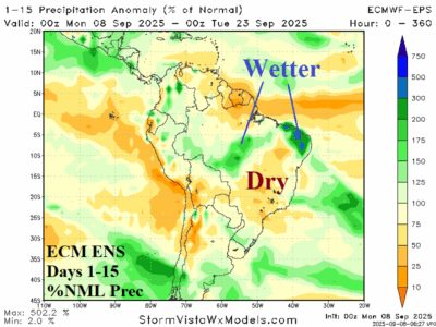
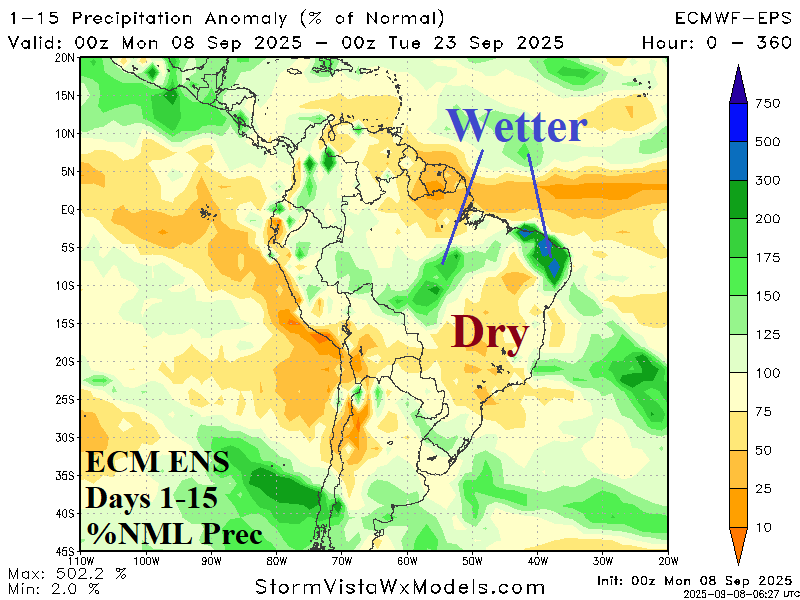
Extended-range Brazil Wet Weather Risk Easing Back

Extended-range forecasts offered beneficial rainfall to the Brazil drought area dating back to September 1st. How are these forecasts tracking? Generally, the wet risk remains although less impactful on the core of the drought area in East-central Brazil. ECM ENS has developing nearby rains during the medium range but leaves East Brazil dry in the latest 15-day forecast. GFS is trending somewhat drier. In the 16-30-day period, ECM is considerably less aggressive forecast wet weather in Brazil biasing the wet anomaly farther to the north.
09/08/2025, 5:44 am EDT
A map of the world AI-generated content may be incorrect.

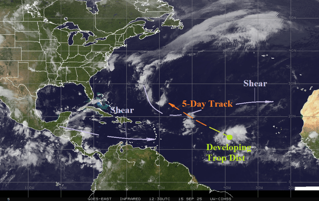
Is Upper Air Pattern Associated NAWH Inhibiting TC Season?

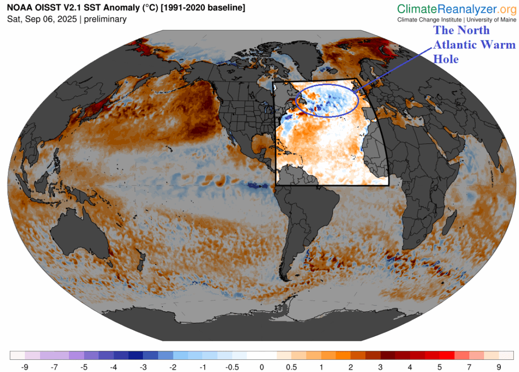
Vividly present is the NAWH pattern south of Greenland. Aloft, the cooler water is linked to a summer of 2025 upper trough. The 15-day forecast maintains this pattern. The upper trough forces the subtropical ridge farther south. The ridge is forcing dry air into the subtropics/northern tropics inhibiting tropical cyclone development.
09/07/2025, 12:04 pm EDT
A map of the weather AI-generated content may be incorrect.

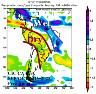
South America and Australia Spring 2025 Outlook Review

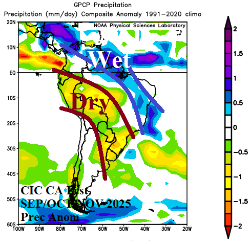
In South America, a drier than normal projection is indicated with average confidence stretching from Peru to Bolivia to Northeast Argentina and Southeast Brazil. A wet regime is likely across northern continent to Northeast Brazil. Anomalous heat builds across northern continent to Central Brazil and across North Chile. The outlooks are based on an analog whereas La Nina and negative Indian Ocean dipole (-IOD) are present during spring coupled with large marine heat waves east of Argentina and east of Australia and New Zealand.